Ponoka geodata
Ponoka (Alberta) is a populated place; located in Canada in America/Edmonton (GMT-6) time zone. With population of 6,656 people, there are 413 cities with bigger population in this country. Compared to other cities in Canada, 88.2% of cities are located further ↓South; 79.8% of cities are located further →East and 94.8% of cities have lower elevation than Ponoka. Note1


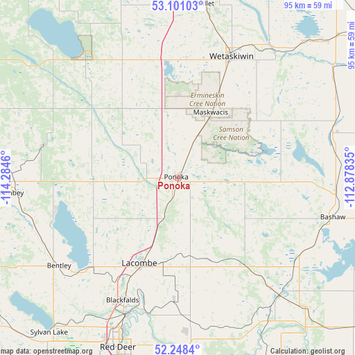
Ponoka GPS coordinates[2]
52° 40' 36.48" North, 113° 34' 53.292" West
| Map corner | latitude | longitude |
|---|---|---|
| Upper-left | 53.10103°, | -114.2846° |
| Center: | 52.6768°, | -113.58147° |
| Lower-right: | 52.2484°, | -112.87835° |
| Map W x H: | 94.8×94.8 km | = 58.9×58.9mi |
| max Lat: | 73.03752° ⇑11.8% North |
| Ponoka: | 52.6768° |
| min Lat: | ⇓88.2% South 42.05009° |
| min Long | Ponoka | max Long |
| -139.43328° | -113.58147° | -52.70931° |
| W 20.2%⇐ | ⇒79.8% E |
Elevation
Elevation of Ponoka is 806 m = 2644 ft, and this is 551.6 m = 1810 ft above average elevation for this country.
| Max E: |
1518 m = 4980 ft | 5.2% |
| Ponoka | 806 m 2644 ft | |
| Avg. | 254.4 m = 835 ft | |
Min E: |
-2 m = -7 ft | 94.8% |
See also: Canada elevation on elevation.city.
Geographical zone
Ponoka is located in North temperate zone (between Tropic of Cancer and the Arctic Circle). Distance of this North polar circle is 1544.1 km =959.5 mi to North.| Distance of | km | miles | from Ponoka |
|---|---|---|---|
| North Pole | 4150 | 2578.7 | to North |
| Arctic Circle | 1544.1 | 959.5 | to North |
| Tropic Cancer | 3251.2 | 2020.2 | to South |
| Equator | 5857.1 | 3639.4 | to South |


Nearby cities:
15 places around Ponoka: (largest is in red/bold)
• Beaumont
75.7 km =47 mi,  8°
8°
• Blackfalds
35.4 km =22 mi,  202°
202°
• Calmar
67.5 km =41.9 mi,  346°
346°
• Camrose
62.8 km =39 mi,  52°
52°
• Devon
77.4 km =48.1 mi, 352°
• Lacombe
25.6 km =15.9 mi, 203°
• Leduc
65.6 km =40.8 mi,  1°
1°
• Millet
47.7 km =29.6 mi, 9°
• Penhold
63.5 km =39.5 mi, 197°
• Red Deer
48 km =29.8 mi, 198°
• Rimbey
44.4 km =27.6 mi,  263°
263°
• Springbrook
58.9 km =36.6 mi, 200°
• Stettler
70.8 km =44 mi,  124°
124°
• Sylvan Lake
53 km =32.9 mi,  219°
219°
• Wetaskiwin
35.3 km =21.9 mi,  23°
23°
Sources, notices
• [Note1] Compared only with cities in Canada existing in our database
• [Src1] Map data: © OpenStreetMap contributors (CC-BY-SA)
• [Src2] Other city data from geonames.org with taken over terms of usage.
• [Src3] Geographical zone / Annual Mean Temperature by Robert A. Rohde @ Wikipedia
