Lacombe geodata
Lacombe (Alberta) is a populated place; located in Canada in America/Edmonton (GMT-6) time zone. With population of 10,059 people, there are 309 cities with bigger population in this country. Compared to other cities in Canada, 88% of cities are located further ↓South; 80.2% of cities are located further →East and 95.5% of cities have lower elevation than Lacombe. Note1


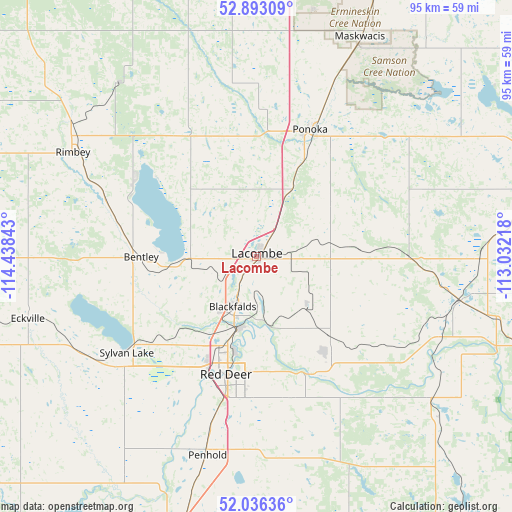
Lacombe GPS coordinates[2]
52° 28' 0.516" North, 113° 44' 7.08" West
| Map corner | latitude | longitude |
|---|---|---|
| Upper-left | 52.89309°, | -114.43843° |
| Center: | 52.46681°, | -113.7353° |
| Lower-right: | 52.03636°, | -113.03218° |
| Map W x H: | 95.3×95.3 km | = 59.2×59.2mi |
| max Lat: | 73.03752° ⇑12% North |
| Lacombe: | 52.46681° |
| min Lat: | ⇓88% South 42.05009° |
| min Long | Lacombe | max Long |
| -139.43328° | -113.7353° | -52.70931° |
| W 19.8%⇐ | ⇒80.2% E |
Elevation
Elevation of Lacombe is 853 m = 2799 ft, and this is 598.6 m = 1964 ft above average elevation for this country.
| Max E: |
1518 m = 4980 ft | 4.5% |
| Lacombe | 853 m 2799 ft | |
| Avg. | 254.4 m = 835 ft | |
Min E: |
-2 m = -7 ft | 95.5% |
See also: Canada elevation on elevation.city.
Geographical zone
Lacombe is located in North temperate zone (between Tropic of Cancer and the Arctic Circle). Distance of this North polar circle is 1567.4 km =973.9 mi to North.| Distance of | km | miles | from Lacombe |
|---|---|---|---|
| North Pole | 4173.3 | 2593.2 | to North |
| Arctic Circle | 1567.4 | 973.9 | to North |
| Tropic Cancer | 3227.8 | 2005.7 | to South |
| Equator | 5833.8 | 3625 | to South |


Nearby cities:
15 places around Lacombe: (largest is in red/bold)
• Blackfalds
9.9 km =6.2 mi,  200°
200°
• Calmar
89.1 km =55.4 mi,  356°
356°
• Camrose
86.1 km =53.5 mi,  44°
44°
• Leduc
89.8 km =55.8 mi,  7°
7°
• Millet
72.7 km =45.2 mi, 14°
• Olds
80 km =49.7 mi, 198°
• Penhold
38.2 km =23.7 mi,  193°
193°
• Ponoka
25.6 km =15.9 mi,  23°
23°
• Red Deer
22.7 km =14.1 mi, 191°
• Rimbey
38.5 km =23.9 mi,  298°
298°
• Rocky Mountain House
81 km =50.3 mi,  262°
262°
• Springbrook
33.5 km =20.8 mi, 197°
• Stettler
71 km =44.1 mi,  103°
103°
• Sylvan Lake
29.3 km =18.2 mi,  233°
233°
• Wetaskiwin
60.8 km =37.8 mi, 23°
Sources, notices
• [Note1] Compared only with cities in Canada existing in our database
• [Src1] Map data: © OpenStreetMap contributors (CC-BY-SA)
• [Src2] Other city data from geonames.org with taken over terms of usage.
• [Src3] Geographical zone / Annual Mean Temperature by Robert A. Rohde @ Wikipedia
