Peterborough geodata
Peterborough (Ontario) is a populated place; located in Canada in America/Toronto (GMT-4) time zone. With population of 75,877 people, there are 72 cities with bigger population in this country. Compared to other cities in Canada, 88.9% of cities are located further ↑North; 51.4% of cities are located further ←West and 53% of cities have lower elevation than Peterborough. Note1


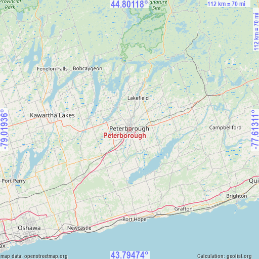
Peterborough GPS coordinates[2]
44° 18' 0.432" North, 78° 18' 58.428" West
| Map corner | latitude | longitude |
|---|---|---|
| Upper-left | 44.80118°, | -79.01936° |
| Center: | 44.30012°, | -78.31623° |
| Lower-right: | 43.79474°, | -77.61311° |
| Map W x H: | 111.9×111.9 km | = 69.5×69.5mi |
| max Lat: | 73.03752° ⇑88.9% North |
| Peterborough: | 44.30012° |
| min Lat: | ⇓11.1% South 42.05009° |
| min Long | Peterborough | max Long |
| -139.43328° | -78.31623° | -52.70931° |
| W 51.4%⇐ | ⇒48.6% E |
Elevation
Elevation of Peterborough is 188 m = 617 ft, and this is 66.4 m = 218 ft below average elevation for this country.
| Max E: |
1518 m = 4980 ft | 47% |
| Avg. | 254.4 m = 835 ft | |
| Peterborough | 188 m = 617 ft | |
Min E: |
-2 m = -7 ft | 53% |
See also: Peterborough elevation on elevation.city.
Geographical zone
Peterborough is located in North temperate zone (between Tropic of Cancer and the Arctic Circle). Distance of this Northern Tropic circle is 2319.8 km =1441.5 mi to South.| Distance of | km | miles | from Peterborough |
|---|---|---|---|
| North Pole | 5081.4 | 3157.4 | to North |
| Arctic Circle | 2475.5 | 1538.2 | to North |
| Tropic Cancer | 2319.8 | 1441.5 | to South |
| Equator | 4925.7 | 3060.7 | to South |


Nearby cities:
15 places around Peterborough: (largest is in red/bold)
• Blackstock
45.6 km =28.3 mi,  240°
240°
• Caesarea
44.4 km =27.6 mi,  247°
247°
• Cobourg
39.7 km =24.7 mi,  162°
162°
• Greenbank
58.2 km =36.2 mi, 253°
• Lakefield
15.3 km =9.5 mi,  15°
15°
• Lindsay
33.6 km =20.9 mi,  279°
279°
• Madoc
70.8 km =44 mi,  70°
70°
• Millbrook
19.8 km =12.3 mi,  212°
212°
• Norwood
28.1 km =17.5 mi, 70°
• Omemee
19.4 km =12.1 mi,  269°
269°
• Oshawa
61.6 km =38.3 mi,  223°
223°
• Port Hope
32.2 km =20 mi,  191°
191°
• Quinte West
61.1 km =38 mi,  102°
102°
• Stirling
61 km =37.9 mi,  90°
90°
• Uxbridge
67.5 km =41.9 mi, 250°
Sources, notices
• [Note1] Compared only with cities in Canada existing in our database
• [Src1] Map data: © OpenStreetMap contributors (CC-BY-SA)
• [Src2] Other city data from geonames.org with taken over terms of usage.
• [Src3] Geographical zone / Annual Mean Temperature by Robert A. Rohde @ Wikipedia
