Port Hope geodata
Port Hope (Ontario) is a populated place; located in Canada in America/Toronto (GMT-4) time zone. With population of 12,587 people, there are 269 cities with bigger population in this country. Compared to other cities in Canada, 91.7% of cities are located further ↑North; 51.3% of cities are located further ←West and 54.4% of cities have higher elevation than Port Hope. Note1


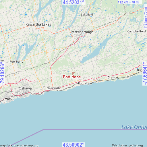
Port Hope GPS coordinates[2]
44° 1' 0.552" North, 78° 23' 58.308" West
| Map corner | latitude | longitude |
|---|---|---|
| Upper-left | 44.52031°, | -79.10266° |
| Center: | 44.01682°, | -78.39953° |
| Lower-right: | 43.50902°, | -77.69641° |
| Map W x H: | 112.4×112.4 km | = 69.8×69.8mi |
| max Lat: | 73.03752° ⇑91.7% North |
| Port Hope: | 44.01682° |
| min Lat: | ⇓8.3% South 42.05009° |
| min Long | Port Hope | max Long |
| -139.43328° | -78.39953° | -52.70931° |
| W 51.3%⇐ | ⇒48.7% E |
Elevation
Elevation of Port Hope is 144 m = 472 ft, and this is 110.4 m = 362 ft below average elevation for this country.
| Max E: |
1518 m = 4980 ft | 54.4% |
| Avg. | 254.4 m = 835 ft | |
| Port Hope | 144 m = 472 ft | |
Min E: |
-2 m = -7 ft | 45.6% |
See also: Canada elevation on elevation.city.
Geographical zone
Port Hope is located in North temperate zone (between Tropic of Cancer and the Arctic Circle). Distance of this Northern Tropic circle is 2288.3 km =1421.9 mi to South.| Distance of | km | miles | from Port Hope |
|---|---|---|---|
| North Pole | 5112.9 | 3177 | to North |
| Arctic Circle | 2507 | 1557.8 | to North |
| Tropic Cancer | 2288.3 | 1421.9 | to South |
| Equator | 4894.2 | 3041.1 | to South |


Nearby cities:
15 places around Port Hope: (largest is in red/bold)
• Ajax
54 km =33.6 mi,  249°
249°
• Blackstock
34.6 km =21.5 mi,  285°
285°
• Caesarea
37.7 km =23.4 mi, 293°
• Cobourg
19.8 km =12.3 mi,  108°
108°
• Goodwood
64 km =39.8 mi,  271°
271°
• Greenbank
51.4 km =31.9 mi, 286°
• Lakefield
47.5 km =29.5 mi,  12°
12°
• Lindsay
45.6 km =28.3 mi,  324°
324°
• Millbrook
15.4 km =9.6 mi,  344°
344°
• Norwood
52.6 km =32.7 mi,  39°
39°
• Omemee
33.9 km =21.1 mi, 337°
• Oshawa
38.3 km =23.8 mi, 250°
• Peterborough
32.2 km =20 mi, 11°
• Pickering
60.1 km =37.3 mi,  257°
257°
• Uxbridge
58 km =36 mi,  279°
279°
Sources, notices
• [Note1] Compared only with cities in Canada existing in our database
• [Src1] Map data: © OpenStreetMap contributors (CC-BY-SA)
• [Src2] Other city data from geonames.org with taken over terms of usage.
• [Src3] Geographical zone / Annual Mean Temperature by Robert A. Rohde @ Wikipedia
