Lindsay geodata
Lindsay (Ontario) is a populated place; located in Canada in America/Toronto (GMT-4) time zone. With population of 20,354 people, there are 187 cities with bigger population in this country. Compared to other cities in Canada, 88.4% of cities are located further ↑North; 50.9% of cities are located further ←West and 65.8% of cities have lower elevation than Lindsay. Note1


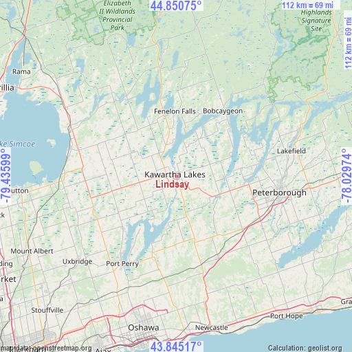
Lindsay GPS coordinates[2]
44° 21' 0.432" North, 78° 43' 58.296" West
| Map corner | latitude | longitude |
|---|---|---|
| Upper-left | 44.85075°, | -79.43599° |
| Center: | 44.35012°, | -78.73286° |
| Lower-right: | 43.84517°, | -78.02974° |
| Map W x H: | 111.8×111.8 km | = 69.5×69.5mi |
| max Lat: | 73.03752° ⇑88.4% North |
| Lindsay: | 44.35012° |
| min Lat: | ⇓11.6% South 42.05009° |
| min Long | Lindsay | max Long |
| -139.43328° | -78.73286° | -52.70931° |
| W 50.9%⇐ | ⇒49.1% E |
Elevation
Elevation of Lindsay is 261 m = 856 ft, and this is 6.6 m = 22 ft above average elevation for this country.
| Max E: |
1518 m = 4980 ft | 34.2% |
| Lindsay | 261 m 856 ft | |
| Avg. | 254.4 m = 835 ft | |
Min E: |
-2 m = -7 ft | 65.8% |
See also: Canada elevation on elevation.city.
Geographical zone
Lindsay is located in North temperate zone (between Tropic of Cancer and the Arctic Circle). Distance of this Northern Tropic circle is 2325.4 km =1444.9 mi to South.| Distance of | km | miles | from Lindsay |
|---|---|---|---|
| North Pole | 5075.8 | 3154 | to North |
| Arctic Circle | 2469.9 | 1534.7 | to North |
| Tropic Cancer | 2325.4 | 1444.9 | to South |
| Equator | 4931.3 | 3064.2 | to South |


Nearby cities:
15 places around Lindsay: (largest is in red/bold)
• Ballantrae
57.3 km =35.6 mi,  232°
232°
• Blackstock
28.6 km =17.8 mi,  193°
193°
• Caesarea
23.6 km =14.7 mi,  199°
199°
• Goodwood
51.2 km =31.8 mi, 226°
• Greenbank
31.7 km =19.7 mi, 225°
• Lakefield
38.2 km =23.7 mi,  75°
75°
• Millbrook
31.7 km =19.7 mi,  134°
134°
• Mount Albert
52.3 km =32.5 mi,  242°
242°
• Omemee
14.9 km =9.3 mi,  112°
112°
• Oshawa
50.9 km =31.6 mi, 190°
• Peterborough
33.6 km =20.9 mi,  99°
99°
• Pickering
59.4 km =36.9 mi,  212°
212°
• Port Hope
45.6 km =28.3 mi,  144°
144°
• Uxbridge
41.3 km =25.7 mi, 227°
• Zephyr
45.6 km =28.3 mi,  248°
248°
Sources, notices
• [Note1] Compared only with cities in Canada existing in our database
• [Src1] Map data: © OpenStreetMap contributors (CC-BY-SA)
• [Src2] Other city data from geonames.org with taken over terms of usage.
• [Src3] Geographical zone / Annual Mean Temperature by Robert A. Rohde @ Wikipedia
