Omemee geodata
Omemee (Ontario) is a populated place; located in Canada in America/Toronto (GMT-4) time zone. With population of 1,323 people, there are 909 cities with bigger population in this country. Compared to other cities in Canada, 89.1% of cities are located further ↑North; 51.1% of cities are located further ←West and 64.2% of cities have lower elevation than Omemee. Note1


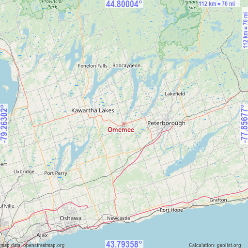
Omemee GPS coordinates[2]
44° 17' 56.292" North, 78° 33' 35.604" West
| Map corner | latitude | longitude |
|---|---|---|
| Upper-left | 44.80004°, | -79.26302° |
| Center: | 44.29897°, | -78.55989° |
| Lower-right: | 43.79358°, | -77.85677° |
| Map W x H: | 111.9×111.9 km | = 69.5×69.5mi |
| max Lat: | 73.03752° ⇑89.1% North |
| Omemee: | 44.29897° |
| min Lat: | ⇓10.9% South 42.05009° |
| min Long | Omemee | max Long |
| -139.43328° | -78.55989° | -52.70931° |
| W 51.1%⇐ | ⇒48.9% E |
Elevation
Elevation of Omemee is 252 m = 827 ft, and this is 2.4 m = 8 ft below average elevation for this country.
| Max E: |
1518 m = 4980 ft | 35.8% |
| Avg. | 254.4 m = 835 ft | |
| Omemee | 252 m = 827 ft | |
Min E: |
-2 m = -7 ft | 64.2% |
See also: Canada elevation on elevation.city.
Geographical zone
Omemee is located in North temperate zone (between Tropic of Cancer and the Arctic Circle). Distance of this Northern Tropic circle is 2319.7 km =1441.4 mi to South.| Distance of | km | miles | from Omemee |
|---|---|---|---|
| North Pole | 5081.5 | 3157.5 | to North |
| Arctic Circle | 2475.6 | 1538.3 | to North |
| Tropic Cancer | 2319.7 | 1441.4 | to South |
| Equator | 4925.6 | 3060.6 | to South |


Nearby cities:
15 places around Omemee: (largest is in red/bold)
• Ajax
62.6 km =38.9 mi,  217°
217°
• Blackstock
30.1 km =18.7 mi, 222°
• Caesarea
27.3 km =17 mi,  232°
232°
• Cobourg
49.1 km =30.5 mi,  140°
140°
• Goodwood
58.9 km =36.6 mi,  239°
239°
• Greenbank
40 km =24.9 mi,  245°
245°
• Lakefield
27.7 km =17.2 mi,  57°
57°
• Lindsay
14.9 km =9.3 mi,  292°
292°
• Millbrook
18.7 km =11.6 mi,  152°
152°
• Norwood
46.8 km =29.1 mi,  78°
78°
• Oshawa
50 km =31.1 mi,  207°
207°
• Peterborough
19.4 km =12.1 mi,  89°
89°
• Port Hope
33.9 km =21.1 mi,  157°
157°
• Uxbridge
49.6 km =30.8 mi, 243°
• Zephyr
57.3 km =35.6 mi,  258°
258°
Sources, notices
• [Note1] Compared only with cities in Canada existing in our database
• [Src1] Map data: © OpenStreetMap contributors (CC-BY-SA)
• [Src2] Other city data from geonames.org with taken over terms of usage.
• [Src3] Geographical zone / Annual Mean Temperature by Robert A. Rohde @ Wikipedia
