Revelstoke geodata
Revelstoke (British Columbia) is a populated place; located in Canada in America/Vancouver (GMT-7) time zone. With population of 7,533 people, there are 377 cities with bigger population in this country. Compared to other cities in Canada, 82.1% of cities are located further ↓South; 86.3% of cities are located further →East and 80.3% of cities have lower elevation than Revelstoke. Note1
Administrative division(s):
- Level 1: British Columbia
- Level 2: Columbia-Shuswap Regional District
- Level 3: Revelstoke


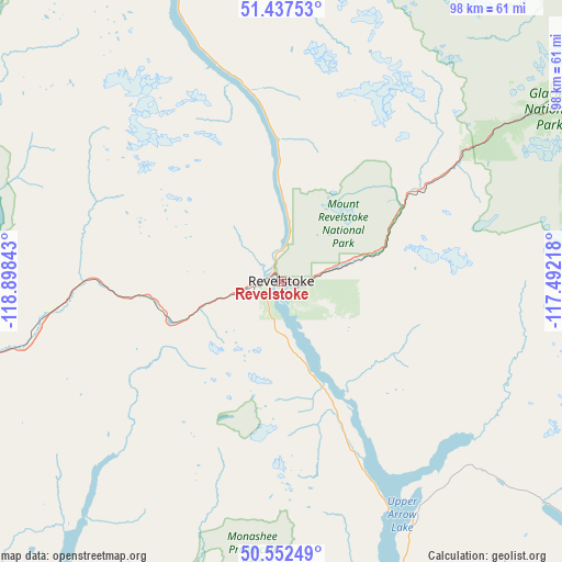
Revelstoke GPS coordinates[2]
50° 59' 49.632" North, 118° 11' 43.08" West
| Map corner | latitude | longitude |
|---|---|---|
| Upper-left | 51.43753°, | -118.89843° |
| Center: | 50.99712°, | -118.1953° |
| Lower-right: | 50.55249°, | -117.49218° |
| Map W x H: | 98.4×98.4 km | = 61.1×61.1mi |
| max Lat: | 73.03752° ⇑17.9% North |
| Revelstoke: | 50.99712° |
| min Lat: | ⇓82.1% South 42.05009° |
| min Long | Revelstoke | max Long |
| -139.43328° | -118.1953° | -52.70931° |
| W 13.7%⇐ | ⇒86.3% E |
Elevation
Elevation of Revelstoke is 459 m = 1506 ft, and this is 204.6 m = 671 ft above average elevation for this country.
| Max E: |
1518 m = 4980 ft | 19.7% |
| Revelstoke | 459 m 1506 ft | |
| Avg. | 254.4 m = 835 ft | |
Min E: |
-2 m = -7 ft | 80.3% |
See also: Canada elevation on elevation.city.
Geographical zone
Revelstoke is located in North temperate zone (between Tropic of Cancer and the Arctic Circle). Distance of this North polar circle is 1730.8 km =1075.5 mi to North.| Distance of | km | miles | from Revelstoke |
|---|---|---|---|
| North Pole | 4336.7 | 2694.7 | to North |
| Arctic Circle | 1730.8 | 1075.5 | to North |
| Tropic Cancer | 3064.4 | 1904.1 | to South |
| Equator | 5670.3 | 3523.4 | to South |


Nearby cities:
15 places around Revelstoke: (largest is in red/bold)
• Armstrong
93.4 km =58 mi,  229°
229°
• Chase
106.4 km =66.1 mi,  259°
259°
• Enderby
83.7 km =52 mi, 233°
• Falkland
110.3 km =68.5 mi,  239°
239°
• Golden
91.9 km =57.1 mi,  68°
68°
• Lumby
99.4 km =61.8 mi,  213°
213°
• Nakusp
87.6 km =54.4 mi,  161°
161°
• Okanagan
107.6 km =66.9 mi, 229°
• Ranchero
80.4 km =50 mi, 241°
• Salmon Arm
84.5 km =52.5 mi,  246°
246°
• Scotch Creek
88.7 km =55.1 mi, 262°
• Sicamous
58.3 km =36.2 mi, 251°
• Sunnybrae
79.6 km =49.5 mi, 251°
• Vernon
111.2 km =69.1 mi,  223°
223°
• White Lake
78.6 km =48.8 mi, 260°
Sources, notices
• [Note1] Compared only with cities in Canada existing in our database
• [Src1] Map data: © OpenStreetMap contributors (CC-BY-SA)
• [Src2] Other city data from geonames.org with taken over terms of usage.
• [Src3] Geographical zone / Annual Mean Temperature by Robert A. Rohde @ Wikipedia
