Hérouxville geodata
Hérouxville (Quebec) is a populated place; located in Canada in America/Toronto (GMT-4) time zone. With population of 1,340 people, there are 903 cities with bigger population in this country. Compared to other cities in Canada, 54.4% of cities are located further ↑North; 73.9% of cities are located further ←West and 54.5% of cities have higher elevation than Hérouxville. Note1


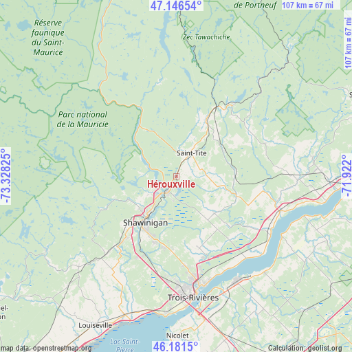
Hérouxville GPS coordinates[2]
46° 39' 58.212" North, 72° 37' 30.432" West
| Map corner | latitude | longitude |
|---|---|---|
| Upper-left | 47.14654°, | -73.32825° |
| Center: | 46.66617°, | -72.62512° |
| Lower-right: | 46.1815°, | -71.922° |
| Map W x H: | 107.3×107.3 km | = 66.7×66.7mi |
| max Lat: | 73.03752° ⇑54.4% North |
| Hérouxville: | 46.66617° |
| min Lat: | ⇓45.6% South 42.05009° |
| min Long | Hérouxville | max Long |
| -139.43328° | -72.62512° | -52.70931° |
| W 73.9%⇐ | ⇒26.1% E |
Elevation
Elevation of Hérouxville is 143 m = 469 ft, and this is 111.4 m = 365 ft below average elevation for this country.
| Max E: |
1518 m = 4980 ft | 54.5% |
| Avg. | 254.4 m = 835 ft | |
| Hérouxville | 143 m = 469 ft | |
Min E: |
-2 m = -7 ft | 45.5% |
See also: Canada elevation on elevation.city.
Geographical zone
Hérouxville is located in North temperate zone (between Tropic of Cancer and the Arctic Circle). Distance of this North polar circle is 2212.4 km =1374.7 mi to North.| Distance of | km | miles | from Hérouxville |
|---|---|---|---|
| North Pole | 4818.3 | 2994 | to North |
| Arctic Circle | 2212.4 | 1374.7 | to North |
| Tropic Cancer | 2582.9 | 1604.9 | to South |
| Equator | 5188.8 | 3224.2 | to South |


Nearby cities:
15 places around Hérouxville: (largest is in red/bold)
• Bécancour
39 km =24.2 mi,  157°
157°
• Laurentides
58.1 km =36.1 mi,  26°
26°
• Lotbinière
53.2 km =33.1 mi,  95°
95°
• Louiseville
51.6 km =32.1 mi,  207°
207°
• Maskinongé
57.3 km =35.6 mi, 211°
• Nicolet
50 km =31.1 mi,  179°
179°
• Portneuf
56.1 km =34.9 mi,  87°
87°
• Saint-Marc-des-Carrières
44 km =27.3 mi, 87°
• Saint-Pierre-les-Becquets
37.4 km =23.2 mi,  119°
119°
• Saint-Tite
8.7 km =5.4 mi, 31°
• Sainte-Catherine
38.9 km =24.2 mi,  173°
173°
• Sainte-Thècle
19.3 km =12 mi, 29°
• Shawinigan
14.6 km =9.1 mi,  220°
220°
• Trois-Rivières
36.2 km =22.5 mi, 170°
• Yamachiche
47.2 km =29.3 mi,  199°
199°
Sources, notices
• [Note1] Compared only with cities in Canada existing in our database
• [Src1] Map data: © OpenStreetMap contributors (CC-BY-SA)
• [Src2] Other city data from geonames.org with taken over terms of usage.
• [Src3] Geographical zone / Annual Mean Temperature by Robert A. Rohde @ Wikipedia
