Squamish geodata
Squamish (British Columbia) is a populated place; located in Canada in America/Vancouver (GMT-7) time zone. With population of 17,587 people, there are 209 cities with bigger population in this country. Compared to other cities in Canada, 72.5% of cities are located further ↓South; 93.8% of cities are located further →East and 97.8% of cities have higher elevation than Squamish. Note1
Administrative division(s):
- Level 1: British Columbia
- Level 2: Squamish-Lillooet Regional District
- Level 3: Squamish


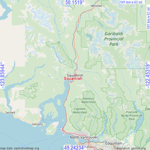
Squamish GPS coordinates[2]
49° 41' 57.3" North, 123° 9' 22.716" West
| Map corner | latitude | longitude |
|---|---|---|
| Upper-left | 50.1519°, | -123.85944° |
| Center: | 49.69925°, | -123.15631° |
| Lower-right: | 49.24234°, | -122.45319° |
| Map W x H: | 101.1×101.1 km | = 62.8×62.8mi |
| max Lat: | 73.03752° ⇑27.5% North |
| Squamish: | 49.69925° |
| min Lat: | ⇓72.5% South 42.05009° |
| min Long | Squamish | max Long |
| -139.43328° | -123.15631° | -52.70931° |
| W 6.2%⇐ | ⇒93.8% E |
Elevation
Elevation of Squamish is 4 m = 13 ft, and this is 250.4 m = 822 ft below average elevation for this country.
| Max E: |
1518 m = 4980 ft | 97.8% |
| Avg. | 254.4 m = 835 ft | |
| Squamish | 4 m = 13 ft | |
Min E: |
-2 m = -7 ft | 2.2% |
See also: Canada elevation on elevation.city.
Geographical zone
Squamish is located in North temperate zone (between Tropic of Cancer and the Arctic Circle). Distance of this North polar circle is 1875.1 km =1165.1 mi to North.| Distance of | km | miles | from Squamish |
|---|---|---|---|
| North Pole | 4481 | 2784.4 | to North |
| Arctic Circle | 1875.1 | 1165.1 | to North |
| Tropic Cancer | 2920.1 | 1814.5 | to South |
| Equator | 5526 | 3433.7 | to South |


Nearby cities:
15 places around Squamish: (largest is in red/bold)
• Anmore
47.9 km =29.8 mi,  152°
152°
• Arbutus Ridge
50 km =31.1 mi,  181°
181°
• Bowen Island
37.3 km =23.2 mi,  200°
200°
• Burnaby
50.3 km =31.3 mi,  163°
163°
• Coquitlam
53.4 km =33.2 mi, 149°
• Gibsons
42.1 km =26.2 mi,  216°
216°
• Lions Bay
28.1 km =17.5 mi,  192°
192°
• North Vancouver
43 km =26.7 mi,  171°
171°
• Port Coquitlam
55.7 km =34.6 mi, 149°
• Port Moody
52.3 km =32.5 mi, 152°
• Sechelt
50.1 km =31.1 mi,  240°
240°
• Vancouver
50.1 km =31.1 mi, 176°
• West End
46.3 km =28.8 mi, 177°
• West Vancouver
37 km =23 mi, 181°
• Whistler
48.8 km =30.3 mi,  17°
17°
Sources, notices
• [Note1] Compared only with cities in Canada existing in our database
• [Src1] Map data: © OpenStreetMap contributors (CC-BY-SA)
• [Src2] Other city data from geonames.org with taken over terms of usage.
• [Src3] Geographical zone / Annual Mean Temperature by Robert A. Rohde @ Wikipedia
