Gibsons geodata
Gibsons (British Columbia) is a populated place; located in Canada in America/Vancouver (GMT-7) time zone. With population of 6,821 people, there are 407 cities with bigger population in this country. Compared to other cities in Canada, 69.2% of cities are located further ↓South; 95% of cities are located further →East and 89.1% of cities have higher elevation than Gibsons. Note1
Administrative division(s):
- Level 1: British Columbia
- Level 2: Sunshine Coast Regional District
- Level 3: Gibsons


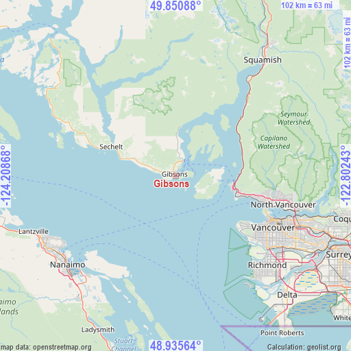
Gibsons GPS coordinates[2]
49° 23' 43.404" North, 123° 30' 19.98" West
| Map corner | latitude | longitude |
|---|---|---|
| Upper-left | 49.85088°, | -124.20868° |
| Center: | 49.39539°, | -123.50555° |
| Lower-right: | 48.93564°, | -122.80243° |
| Map W x H: | 101.8×101.8 km | = 63.3×63.3mi |
| max Lat: | 73.03752° ⇑30.8% North |
| Gibsons: | 49.39539° |
| min Lat: | ⇓69.2% South 42.05009° |
| min Long | Gibsons | max Long |
| -139.43328° | -123.50555° | -52.70931° |
| W 5%⇐ | ⇒95% E |
Elevation
Elevation of Gibsons is 16 m = 52 ft, and this is 238.4 m = 782 ft below average elevation for this country.
| Max E: |
1518 m = 4980 ft | 89.1% |
| Avg. | 254.4 m = 835 ft | |
| Gibsons | 16 m = 52 ft | |
Min E: |
-2 m = -7 ft | 10.9% |
See also: Canada elevation on elevation.city.
Geographical zone
Gibsons is located in North temperate zone (between Tropic of Cancer and the Arctic Circle). Distance of this North polar circle is 1908.9 km =1186.1 mi to North.| Distance of | km | miles | from Gibsons |
|---|---|---|---|
| North Pole | 4514.8 | 2805.4 | to North |
| Arctic Circle | 1908.9 | 1186.1 | to North |
| Tropic Cancer | 2886.3 | 1793.5 | to South |
| Equator | 5492.3 | 3412.8 | to South |


Nearby cities:
15 places around Gibsons: (largest is in red/bold)
• Arbutus Ridge
29.3 km =18.2 mi,  123°
123°
• Bowen Island
12.3 km =7.6 mi,  95°
95°
• Burnaby
42.6 km =26.5 mi,  109°
109°
• Cedar
40 km =24.9 mi,  219°
219°
• East Wellington
44.6 km =27.7 mi,  236°
236°
• Lions Bay
20.4 km =12.7 mi,  71°
71°
• Nanaimo
40.5 km =25.2 mi,  231°
231°
• North Vancouver
32.8 km =20.4 mi, 105°
• Richmond
36.6 km =22.7 mi,  133°
133°
• Sechelt
20.4 km =12.7 mi,  295°
295°
• Squamish
42.1 km =26.2 mi,  36°
36°
• Vancouver
32.3 km =20.1 mi, 120°
• Welcome Beach
29.5 km =18.3 mi,  288°
288°
• West End
29.7 km =18.5 mi, 114°
• West Vancouver
24.7 km =15.3 mi, 97°
Sources, notices
• [Note1] Compared only with cities in Canada existing in our database
• [Src1] Map data: © OpenStreetMap contributors (CC-BY-SA)
• [Src2] Other city data from geonames.org with taken over terms of usage.
• [Src3] Geographical zone / Annual Mean Temperature by Robert A. Rohde @ Wikipedia
