Wellesley geodata
Wellesley (Ontario) is a populated place; located in Canada in America/Toronto (GMT-4) time zone. With population of 3,246 people, there are 587 cities with bigger population in this country. Compared to other cities in Canada, 94.8% of cities are located further ↑North; 58.1% of cities are located further →East and 74.7% of cities have lower elevation than Wellesley. Note1
Administrative division(s):
- Level 1: Ontario
- Level 2: Regional Municipality of Waterloo
- Level 3: Wellesley


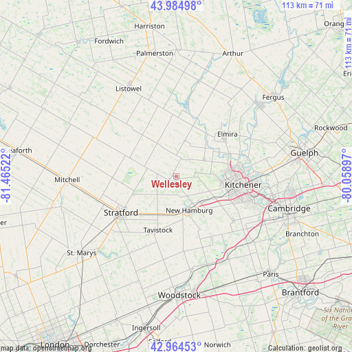
Wellesley GPS coordinates[2]
43° 28' 36.876" North, 80° 45' 43.524" West
| Map corner | latitude | longitude |
|---|---|---|
| Upper-left | 43.98498°, | -81.46522° |
| Center: | 43.47691°, | -80.76209° |
| Lower-right: | 42.96453°, | -80.05897° |
| Map W x H: | 113.5×113.5 km | = 70.5×70.5mi |
| max Lat: | 73.03752° ⇑94.8% North |
| Wellesley: | 43.47691° |
| min Lat: | ⇓5.2% South 42.05009° |
| min Long | Wellesley | max Long |
| -139.43328° | -80.76209° | -52.70931° |
| W 41.9%⇐ | ⇒58.1% E |
Elevation
Elevation of Wellesley is 358 m = 1175 ft, and this is 103.6 m = 340 ft above average elevation for this country.
| Max E: |
1518 m = 4980 ft | 25.3% |
| Wellesley | 358 m 1175 ft | |
| Avg. | 254.4 m = 835 ft | |
Min E: |
-2 m = -7 ft | 74.7% |
See also: Canada elevation on elevation.city.
Geographical zone
Wellesley is located in North temperate zone (between Tropic of Cancer and the Arctic Circle). Distance of this Northern Tropic circle is 2228.3 km =1384.6 mi to South.| Distance of | km | miles | from Wellesley |
|---|---|---|---|
| North Pole | 5172.9 | 3214.3 | to North |
| Arctic Circle | 2567 | 1595.1 | to North |
| Tropic Cancer | 2228.3 | 1384.6 | to South |
| Equator | 4834.2 | 3003.8 | to South |


Nearby cities:
15 places around Wellesley: (largest is in red/bold)
• Cambridge
38.5 km =23.9 mi,  109°
109°
• Guelph
41.5 km =25.8 mi,  79°
79°
• Huron East
46 km =28.6 mi,  289°
289°
• Kitchener
21 km =13 mi, 105°
• Linwood
12 km =7.5 mi,  13°
13°
• Listowel
32.3 km =20.1 mi,  332°
332°
• New Hamburg
11.6 km =7.2 mi,  154°
154°
• North Perth
32.2 km =20 mi, 329°
• Paris
43.4 km =27 mi,  135°
135°
• Plattsville
22.9 km =14.2 mi, 149°
• St. Clements
10.1 km =6.3 mi,  63°
63°
• Stratford
19.5 km =12.1 mi,  231°
231°
• Tavistock
18.7 km =11.6 mi,  197°
197°
• Waterloo
19.9 km =12.4 mi,  93°
93°
• Woodstock
38.2 km =23.7 mi,  178°
178°
Sources, notices
• [Note1] Compared only with cities in Canada existing in our database
• [Src1] Map data: © OpenStreetMap contributors (CC-BY-SA)
• [Src2] Other city data from geonames.org with taken over terms of usage.
• [Src3] Geographical zone / Annual Mean Temperature by Robert A. Rohde @ Wikipedia
