Tavistock geodata
Tavistock (Ontario) is a populated place; located in Canada in America/Toronto (GMT-4) time zone. With population of 2,955 people, there are 618 cities with bigger population in this country. Compared to other cities in Canada, 95.6% of cities are located further ↑North; 58.2% of cities are located further →East and 73.6% of cities have lower elevation than Tavistock. Note1


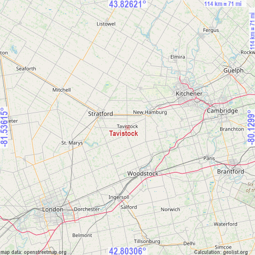
Tavistock GPS coordinates[2]
43° 19' 0.444" North, 80° 49' 58.872" West
| Map corner | latitude | longitude |
|---|---|---|
| Upper-left | 43.82621°, | -81.53615° |
| Center: | 43.31679°, | -80.83302° |
| Lower-right: | 42.80306°, | -80.1299° |
| Map W x H: | 113.8×113.8 km | = 70.7×70.7mi |
| max Lat: | 73.03752° ⇑95.6% North |
| Tavistock: | 43.31679° |
| min Lat: | ⇓4.4% South 42.05009° |
| min Long | Tavistock | max Long |
| -139.43328° | -80.83302° | -52.70931° |
| W 41.8%⇐ | ⇒58.2% E |
Elevation
Elevation of Tavistock is 341 m = 1119 ft, and this is 86.6 m = 284 ft above average elevation for this country.
| Max E: |
1518 m = 4980 ft | 26.4% |
| Tavistock | 341 m 1119 ft | |
| Avg. | 254.4 m = 835 ft | |
Min E: |
-2 m = -7 ft | 73.6% |
See also: Canada elevation on elevation.city.
Geographical zone
Tavistock is located in North temperate zone (between Tropic of Cancer and the Arctic Circle). Distance of this Northern Tropic circle is 2210.5 km =1373.5 mi to South.| Distance of | km | miles | from Tavistock |
|---|---|---|---|
| North Pole | 5190.7 | 3225.4 | to North |
| Arctic Circle | 2584.8 | 1606.1 | to North |
| Tropic Cancer | 2210.5 | 1373.5 | to South |
| Equator | 4816.4 | 2992.8 | to South |


Nearby cities:
15 places around Tavistock: (largest is in red/bold)
• Brant
44.2 km =27.5 mi,  117°
117°
• Burford
40.5 km =25.2 mi,  125°
125°
• Cambridge
42.4 km =26.3 mi,  83°
83°
• Dorchester
41.6 km =25.8 mi,  207°
207°
• Ingersoll
31.8 km =19.8 mi,  187°
187°
• Kitchener
28.7 km =17.8 mi,  65°
65°
• Linwood
30.6 km =19 mi,  16°
16°
• New Hamburg
13.1 km =8.1 mi,  55°
55°
• Paris
38.7 km =24 mi,  109°
109°
• Plattsville
17.6 km =10.9 mi,  96°
96°
• St. Clements
26.7 km =16.6 mi,  33°
33°
• Stratford
11 km =6.8 mi,  300°
300°
• Waterloo
30.5 km =19 mi, 56°
• Wellesley
18.7 km =11.6 mi, 17°
• Woodstock
21.5 km =13.4 mi,  161°
161°
Sources, notices
• [Note1] Compared only with cities in Canada existing in our database
• [Src1] Map data: © OpenStreetMap contributors (CC-BY-SA)
• [Src2] Other city data from geonames.org with taken over terms of usage.
• [Src3] Geographical zone / Annual Mean Temperature by Robert A. Rohde @ Wikipedia
