Huron East geodata
Huron East (Ontario) is a populated place; located in Canada in America/Toronto (GMT-4) time zone. With population of 9,264 people, there are 332 cities with bigger population in this country. Compared to other cities in Canada, 94.2% of cities are located further ↑North; 60.2% of cities are located further →East and 73.1% of cities have lower elevation than Huron East. Note1


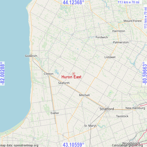
Huron East GPS coordinates[2]
43° 37' 0.444" North, 81° 17' 59.1" West
| Map corner | latitude | longitude |
|---|---|---|
| Upper-left | 44.12368°, | -82.00288° |
| Center: | 43.61679°, | -81.29975° |
| Lower-right: | 43.10559°, | -80.59663° |
| Map W x H: | 113.2×113.2 km | = 70.3×70.3mi |
| max Lat: | 73.03752° ⇑94.2% North |
| Huron East: | 43.61679° |
| min Lat: | ⇓5.8% South 42.05009° |
| min Long | Huron East | max Long |
| -139.43328° | -81.29975° | -52.70931° |
| W 39.8%⇐ | ⇒60.2% E |
Elevation
Elevation of Huron East is 338 m = 1109 ft, and this is 83.6 m = 274 ft above average elevation for this country.
| Max E: |
1518 m = 4980 ft | 26.9% |
| Huron East | 338 m 1109 ft | |
| Avg. | 254.4 m = 835 ft | |
Min E: |
-2 m = -7 ft | 73.1% |
See also: Canada elevation on elevation.city.
Geographical zone
Huron East is located in North temperate zone (between Tropic of Cancer and the Arctic Circle). Distance of this Northern Tropic circle is 2243.8 km =1394.2 mi to South.| Distance of | km | miles | from Huron East |
|---|---|---|---|
| North Pole | 5157.3 | 3204.6 | to North |
| Arctic Circle | 2551.4 | 1585.4 | to North |
| Tropic Cancer | 2243.8 | 1394.2 | to South |
| Equator | 4849.7 | 3013.5 | to South |


Nearby cities:
15 places around Huron East: (largest is in red/bold)
• Bluewater
29.4 km =18.3 mi,  235°
235°
• Brussels
13.6 km =8.5 mi,  17°
17°
• Goderich
36 km =22.4 mi,  292°
292°
• Harriston
46 km =28.6 mi,  46°
46°
• Linwood
46.2 km =28.7 mi,  94°
94°
• Listowel
31 km =19.3 mi,  65°
65°
• Lucan
48.9 km =30.4 mi,  189°
189°
• Mildmay
50.4 km =31.3 mi, 16°
• North Perth
29.3 km =18.2 mi, 65°
• Seaforth
10.9 km =6.8 mi,  227°
227°
• South Huron
37.7 km =23.4 mi,  207°
207°
• Stratford
39.6 km =24.6 mi,  134°
134°
• Tavistock
50.3 km =31.3 mi, 131°
• Wellesley
46 km =28.6 mi,  109°
109°
• Wingham
30.2 km =18.8 mi,  358°
358°
Sources, notices
• [Note1] Compared only with cities in Canada existing in our database
• [Src1] Map data: © OpenStreetMap contributors (CC-BY-SA)
• [Src2] Other city data from geonames.org with taken over terms of usage.
• [Src3] Geographical zone / Annual Mean Temperature by Robert A. Rohde @ Wikipedia
