Listowel geodata
Listowel (Ontario) is a populated place; located in Canada in America/Toronto (GMT-4) time zone. With population of 7,530 people, there are 378 cities with bigger population in this country. Compared to other cities in Canada, 93.5% of cities are located further ↑North; 58.7% of cities are located further →East and 76.9% of cities have lower elevation than Listowel. Note1


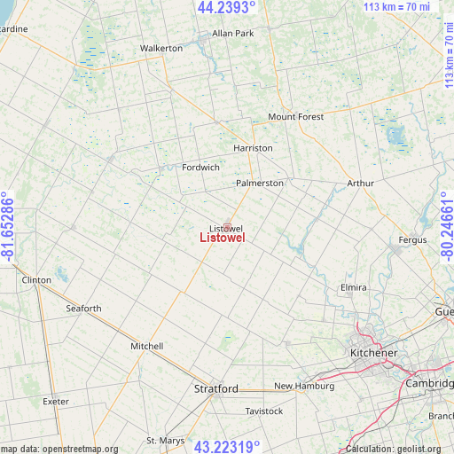
Listowel GPS coordinates[2]
43° 44' 0.24" North, 80° 56' 59.028" West
| Map corner | latitude | longitude |
|---|---|---|
| Upper-left | 44.2393°, | -81.65286° |
| Center: | 43.7334°, | -80.94973° |
| Lower-right: | 43.22319°, | -80.24661° |
| Map W x H: | 113×113 km | = 70.2×70.2mi |
| max Lat: | 73.03752° ⇑93.5% North |
| Listowel: | 43.7334° |
| min Lat: | ⇓6.5% South 42.05009° |
| min Long | Listowel | max Long |
| -139.43328° | -80.94973° | -52.70931° |
| W 41.3%⇐ | ⇒58.7% E |
Elevation
Elevation of Listowel is 381 m = 1250 ft, and this is 126.6 m = 415 ft above average elevation for this country.
| Max E: |
1518 m = 4980 ft | 23.1% |
| Listowel | 381 m 1250 ft | |
| Avg. | 254.4 m = 835 ft | |
Min E: |
-2 m = -7 ft | 76.9% |
See also: Canada elevation on elevation.city.
Geographical zone
Listowel is located in North temperate zone (between Tropic of Cancer and the Arctic Circle). Distance of this Northern Tropic circle is 2256.8 km =1402.3 mi to South.| Distance of | km | miles | from Listowel |
|---|---|---|---|
| North Pole | 5144.4 | 3196.6 | to North |
| Arctic Circle | 2538.5 | 1577.4 | to North |
| Tropic Cancer | 2256.8 | 1402.3 | to South |
| Equator | 4862.7 | 3021.5 | to South |


Nearby cities:
15 places around Listowel: (largest is in red/bold)
• Brussels
24.1 km =15 mi,  269°
269°
• Hanover
46.8 km =29.1 mi,  351°
351°
• Harriston
19.3 km =12 mi,  16°
16°
• Huron East
31 km =19.3 mi,  245°
245°
• Linwood
24.5 km =15.2 mi,  133°
133°
• Mildmay
37.7 km =23.4 mi,  339°
339°
• Neustadt
39.1 km =24.3 mi, 354°
• New Hamburg
43.8 km =27.2 mi,  152°
152°
• North Perth
1.7 km =1.1 mi,  236°
236°
• Seaforth
41.6 km =25.8 mi, 240°
• St. Clements
34.1 km =21.2 mi, 134°
• Stratford
40.8 km =25.4 mi,  179°
179°
• Waterloo
45.8 km =28.5 mi, 130°
• Wellesley
32.3 km =20.1 mi, 152°
• Wingham
33.7 km =20.9 mi,  300°
300°
Sources, notices
• [Note1] Compared only with cities in Canada existing in our database
• [Src1] Map data: © OpenStreetMap contributors (CC-BY-SA)
• [Src2] Other city data from geonames.org with taken over terms of usage.
• [Src3] Geographical zone / Annual Mean Temperature by Robert A. Rohde @ Wikipedia
