Stratford geodata
Stratford (Ontario) is a populated place; located in Canada in America/Toronto (GMT-4) time zone. With population of 30,233 people, there are 145 cities with bigger population in this country. Compared to other cities in Canada, 95.4% of cities are located further ↑North; 58.6% of cities are located further →East and 75.3% of cities have lower elevation than Stratford. Note1


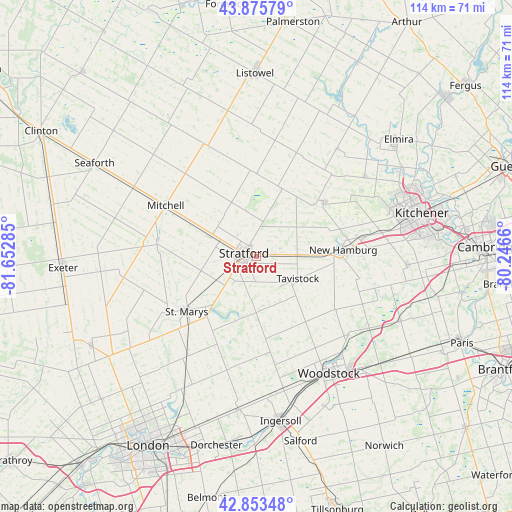
Stratford GPS coordinates[2]
43° 22' 0.444" North, 80° 56' 58.992" West
| Map corner | latitude | longitude |
|---|---|---|
| Upper-left | 43.87579°, | -81.65285° |
| Center: | 43.36679°, | -80.94972° |
| Lower-right: | 42.85348°, | -80.2466° |
| Map W x H: | 113.7×113.7 km | = 70.6×70.6mi |
| max Lat: | 73.03752° ⇑95.4% North |
| Stratford: | 43.36679° |
| min Lat: | ⇓4.6% South 42.05009° |
| min Long | Stratford | max Long |
| -139.43328° | -80.94972° | -52.70931° |
| W 41.4%⇐ | ⇒58.6% E |
Elevation
Elevation of Stratford is 365 m = 1198 ft, and this is 110.6 m = 363 ft above average elevation for this country.
| Max E: |
1518 m = 4980 ft | 24.7% |
| Stratford | 365 m 1198 ft | |
| Avg. | 254.4 m = 835 ft | |
Min E: |
-2 m = -7 ft | 75.3% |
See also: Canada elevation on elevation.city.
Geographical zone
Stratford is located in North temperate zone (between Tropic of Cancer and the Arctic Circle). Distance of this Northern Tropic circle is 2216 km =1377 mi to South.| Distance of | km | miles | from Stratford |
|---|---|---|---|
| North Pole | 5185.1 | 3221.9 | to North |
| Arctic Circle | 2579.2 | 1602.6 | to North |
| Tropic Cancer | 2216 | 1377 | to South |
| Equator | 4821.9 | 2996.2 | to South |


Nearby cities:
15 places around Stratford: (largest is in red/bold)
• Huron East
39.6 km =24.6 mi,  314°
314°
• Ingersoll
37.5 km =23.3 mi,  171°
171°
• Kitchener
36 km =22.4 mi,  79°
79°
• Linwood
29.8 km =18.5 mi,  36°
36°
• Listowel
40.8 km =25.4 mi,  359°
359°
• Lucan
41.8 km =26 mi,  240°
240°
• New Hamburg
20.3 km =12.6 mi, 84°
• North Perth
39.9 km =24.8 mi, 357°
• Plattsville
28 km =17.4 mi,  105°
105°
• Seaforth
41.6 km =25.8 mi,  299°
299°
• St. Clements
29.4 km =18.3 mi,  55°
55°
• Tavistock
11 km =6.8 mi,  120°
120°
• Waterloo
36.7 km =22.8 mi,  72°
72°
• Wellesley
19.5 km =12.1 mi,  51°
51°
• Woodstock
30.6 km =19 mi,  148°
148°
Sources, notices
• [Note1] Compared only with cities in Canada existing in our database
• [Src1] Map data: © OpenStreetMap contributors (CC-BY-SA)
• [Src2] Other city data from geonames.org with taken over terms of usage.
• [Src3] Geographical zone / Annual Mean Temperature by Robert A. Rohde @ Wikipedia
