Miscou geodata
Miscou (New Brunswick) is a populated place; located in Canada in America/Moncton (GMT-3) time zone. With population of 530 people, there are 1169 cities with bigger population in this country. Compared to other cities in Canada, 54% of cities are located further ↓South; 92.3% of cities are located further ←West and 97.3% of cities have higher elevation than Miscou. Note1


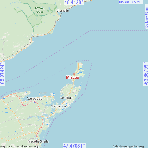
Miscou GPS coordinates[2]
47° 56' 38.22" North, 64° 34' 15.996" West
| Map corner | latitude | longitude |
|---|---|---|
| Upper-left | 48.4128°, | -65.27424° |
| Center: | 47.94395°, | -64.57111° |
| Lower-right: | 47.47081°, | -63.86799° |
| Map W x H: | 104.7×104.7 km | = 65.1×65.1mi |
| max Lat: | 73.03752° ⇑46% North |
| Miscou: | 47.94395° |
| min Lat: | ⇓54% South 42.05009° |
| min Long | Miscou | max Long |
| -139.43328° | -64.57111° | -52.70931° |
| W 92.3%⇐ | ⇒7.7% E |
Elevation
Elevation of Miscou is 5 m = 16 ft, and this is 249.4 m = 818 ft below average elevation for this country.
| Max E: |
1518 m = 4980 ft | 97.3% |
| Avg. | 254.4 m = 835 ft | |
| Miscou | 5 m = 16 ft | |
Min E: |
-2 m = -7 ft | 2.7% |
See also: Canada elevation on elevation.city.
Geographical zone
Miscou is located in North temperate zone (between Tropic of Cancer and the Arctic Circle). Distance of this North polar circle is 2070.3 km =1286.4 mi to North.| Distance of | km | miles | from Miscou |
|---|---|---|---|
| North Pole | 4676.2 | 2905.7 | to North |
| Arctic Circle | 2070.3 | 1286.4 | to North |
| Tropic Cancer | 2724.9 | 1693.2 | to South |
| Equator | 5330.9 | 3312.5 | to South |


Nearby cities:
15 places around Miscou: (largest is in red/bold)
• Bonaventure
69.5 km =43.2 mi,  279°
279°
• Brantville
70.6 km =43.9 mi,  205°
205°
• Chandler
45.8 km =28.5 mi,  349°
349°
• Haut-Sheila
33.6 km =20.9 mi,  229°
229°
• Leech
62.6 km =38.9 mi, 209°
• Maisonnette
34.6 km =21.5 mi,  247°
247°
• New Carlisle
57.4 km =35.7 mi, 277°
• Saint Irénée and Alderwood
58.5 km =36.4 mi, 212°
• Saint-Sauveur
69.6 km =43.2 mi, 228°
• Saint-Simon
30.6 km =19 mi,  221°
221°
• Sainte-Cécile
12.1 km =7.5 mi, 215°
• Saumarez
56.5 km =35.1 mi, 209°
• Shippagan
24.4 km =15.2 mi,  204°
204°
• Tabusintac
76 km =47.2 mi, 205°
• Tracadie-Sheila
54.4 km =33.8 mi, 208°
Sources, notices
• [Note1] Compared only with cities in Canada existing in our database
• [Src1] Map data: © OpenStreetMap contributors (CC-BY-SA)
• [Src2] Other city data from geonames.org with taken over terms of usage.
• [Src3] Geographical zone / Annual Mean Temperature by Robert A. Rohde @ Wikipedia
