Saumarez geodata
Saumarez (New Brunswick) is a section of populated place; located in Canada in America/Moncton (GMT-3) time zone. With population of 502 people, there are 1176 cities with bigger population in this country. Compared to other cities in Canada, 51% of cities are located further ↓South; 90.6% of cities are located further ←West and 81.3% of cities have higher elevation than Saumarez. Note1


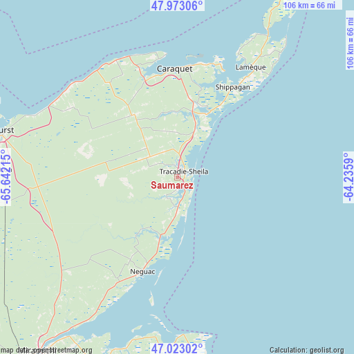
Saumarez GPS coordinates[2]
47° 30' 0.684" North, 64° 56' 20.472" West
| Map corner | latitude | longitude |
|---|---|---|
| Upper-left | 47.97306°, | -65.64215° |
| Center: | 47.50019°, | -64.93902° |
| Lower-right: | 47.02302°, | -64.2359° |
| Map W x H: | 105.6×105.6 km | = 65.6×65.6mi |
| max Lat: | 73.03752° ⇑49% North |
| Saumarez: | 47.50019° |
| min Lat: | ⇓51% South 42.05009° |
| min Long | Saumarez | max Long |
| -139.43328° | -64.93902° | -52.70931° |
| W 90.6%⇐ | ⇒9.4% E |
Elevation
Elevation of Saumarez is 30 m = 98 ft, and this is 224.4 m = 736 ft below average elevation for this country.
| Max E: |
1518 m = 4980 ft | 81.3% |
| Avg. | 254.4 m = 835 ft | |
| Saumarez | 30 m = 98 ft | |
Min E: |
-2 m = -7 ft | 18.7% |
See also: Canada elevation on elevation.city.
Geographical zone
Saumarez is located in North temperate zone (between Tropic of Cancer and the Arctic Circle). Distance of this North polar circle is 2119.6 km =1317.1 mi to North.| Distance of | km | miles | from Saumarez |
|---|---|---|---|
| North Pole | 4725.5 | 2936.3 | to North |
| Arctic Circle | 2119.6 | 1317.1 | to North |
| Tropic Cancer | 2675.6 | 1662.5 | to South |
| Equator | 5281.5 | 3281.8 | to South |


Nearby cities:
15 places around Saumarez: (largest is in red/bold)
• Baie Ste. Anne
49.8 km =30.9 mi,  181°
181°
• Bathurst
55 km =34.2 mi,  283°
283°
• Brantville
14.8 km =9.2 mi,  189°
189°
• Fair Isle
28.3 km =17.6 mi,  209°
209°
• Haut-Sheila
27.5 km =17.1 mi,  4°
4°
• Leech
6.1 km =3.8 mi, 211°
• Maisonnette
36.2 km =22.5 mi,  352°
352°
• Miscou
56.5 km =35.1 mi,  29°
29°
• Saint Irénée and Alderwood
3.6 km =2.2 mi,  267°
267°
• Saint-Sauveur
25 km =15.5 mi, 277°
• Saint-Simon
27.3 km =17 mi,  15°
15°
• Sainte-Cécile
44.4 km =27.6 mi, 27°
• Shippagan
32.2 km =20 mi, 32°
• Tabusintac
19.9 km =12.4 mi,  195°
195°
• Tracadie-Sheila
2.2 km =1.4 mi,  44°
44°
Sources, notices
• [Note1] Compared only with cities in Canada existing in our database
• [Src1] Map data: © OpenStreetMap contributors (CC-BY-SA)
• [Src2] Other city data from geonames.org with taken over terms of usage.
• [Src3] Geographical zone / Annual Mean Temperature by Robert A. Rohde @ Wikipedia
