Brantville geodata
Brantville (New Brunswick) is a populated place; located in Canada in America/Moncton (GMT-3) time zone. With population of 903 people, there are 1073 cities with bigger population in this country. Compared to other cities in Canada, 50.3% of cities are located further ↑North; 90.4% of cities are located further ←West and 86.8% of cities have higher elevation than Brantville. Note1


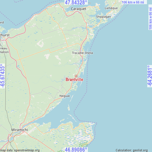
Brantville GPS coordinates[2]
47° 22' 9.192" North, 64° 58' 16.392" West
| Map corner | latitude | longitude |
|---|---|---|
| Upper-left | 47.84328°, | -65.67435° |
| Center: | 47.36922°, | -64.97122° |
| Lower-right: | 46.89086°, | -64.2681° |
| Map W x H: | 105.9×105.9 km | = 65.8×65.8mi |
| max Lat: | 73.03752° ⇑50.3% North |
| Brantville: | 47.36922° |
| min Lat: | ⇓49.7% South 42.05009° |
| min Long | Brantville | max Long |
| -139.43328° | -64.97122° | -52.70931° |
| W 90.4%⇐ | ⇒9.6% E |
Elevation
Elevation of Brantville is 18 m = 59 ft, and this is 236.4 m = 776 ft below average elevation for this country.
| Max E: |
1518 m = 4980 ft | 86.8% |
| Avg. | 254.4 m = 835 ft | |
| Brantville | 18 m = 59 ft | |
Min E: |
-2 m = -7 ft | 13.2% |
See also: Canada elevation on elevation.city.
Geographical zone
Brantville is located in North temperate zone (between Tropic of Cancer and the Arctic Circle). Distance of this North polar circle is 2134.2 km =1326.1 mi to North.| Distance of | km | miles | from Brantville |
|---|---|---|---|
| North Pole | 4740.1 | 2945.4 | to North |
| Arctic Circle | 2134.2 | 1326.1 | to North |
| Tropic Cancer | 2661 | 1653.5 | to South |
| Equator | 5267 | 3272.8 | to South |


Nearby cities:
15 places around Brantville: (largest is in red/bold)
• Baie Ste. Anne
35.3 km =21.9 mi,  177°
177°
• Bathurst
58.1 km =36.1 mi,  298°
298°
• Fair Isle
15.3 km =9.5 mi,  228°
228°
• Haut-Sheila
42.2 km =26.2 mi,  6°
6°
• Leech
9.4 km =5.8 mi,  355°
355°
• Maisonnette
50.6 km =31.4 mi, 357°
• Miramichi
55.1 km =34.2 mi, 226°
• Saint Irénée and Alderwood
14.5 km =9 mi, 355°
• Saint-Sauveur
28.6 km =17.8 mi,  308°
308°
• Saint-Simon
42 km =26.1 mi, 13°
• Sainte-Cécile
58.7 km =36.5 mi,  23°
23°
• Saumarez
14.8 km =9.2 mi, 9°
• Shippagan
46.1 km =28.6 mi,  25°
25°
• Tabusintac
5.5 km =3.4 mi,  213°
213°
• Tracadie-Sheila
16.6 km =10.3 mi, 13°
Sources, notices
• [Note1] Compared only with cities in Canada existing in our database
• [Src1] Map data: © OpenStreetMap contributors (CC-BY-SA)
• [Src2] Other city data from geonames.org with taken over terms of usage.
• [Src3] Geographical zone / Annual Mean Temperature by Robert A. Rohde @ Wikipedia
