Hauterive geodata
Hauterive (Quebec) is a populated place; located in Canada in America/Toronto (GMT-4) time zone. With population of 11,549 people, there are 284 cities with bigger population in this country. Compared to other cities in Canada, 65.8% of cities are located further ↓South; 84.9% of cities are located further ←West and 93.8% of cities have higher elevation than Hauterive. Note1


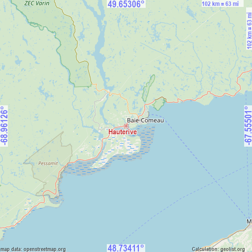
Hauterive GPS coordinates[2]
49° 11' 44.592" North, 68° 15' 29.268" West
| Map corner | latitude | longitude |
|---|---|---|
| Upper-left | 49.65306°, | -68.96126° |
| Center: | 49.19572°, | -68.25813° |
| Lower-right: | 48.73411°, | -67.55501° |
| Map W x H: | 102.2×102.2 km | = 63.5×63.5mi |
| max Lat: | 73.03752° ⇑34.2% North |
| Hauterive: | 49.19572° |
| min Lat: | ⇓65.8% South 42.05009° |
| min Long | Hauterive | max Long |
| -139.43328° | -68.25813° | -52.70931° |
| W 84.9%⇐ | ⇒15.1% E |
Elevation
Elevation of Hauterive is 10 m = 33 ft, and this is 244.4 m = 802 ft below average elevation for this country.
| Max E: |
1518 m = 4980 ft | 93.8% |
| Avg. | 254.4 m = 835 ft | |
| Hauterive | 10 m = 33 ft | |
Min E: |
-2 m = -7 ft | 6.2% |
See also: Canada elevation on elevation.city.
Geographical zone
Hauterive is located in North temperate zone (between Tropic of Cancer and the Arctic Circle). Distance of this North polar circle is 1931.1 km =1199.9 mi to North.| Distance of | km | miles | from Hauterive |
|---|---|---|---|
| North Pole | 4537 | 2819.2 | to North |
| Arctic Circle | 1931.1 | 1199.9 | to North |
| Tropic Cancer | 2864.1 | 1779.7 | to South |
| Equator | 5470.1 | 3399 | to South |


Nearby cities:
15 places around Hauterive: (largest is in red/bold)
• Amqui
101.4 km =63 mi,  143°
143°
• Baie-Comeau
8.3 km =5.2 mi,  73°
73°
• Cap-Chat
115.1 km =71.5 mi,  95°
95°
• Chute-aux-Outardes
13.5 km =8.4 mi,  229°
229°
• Forestville
78.9 km =49 mi, 229°
• Labrieville
95.4 km =59.3 mi,  276°
276°
• Le Bic
96.6 km =60 mi,  199°
199°
• Les Escoumins
126.1 km =78.4 mi,  221°
221°
• Luceville
73.1 km =45.4 mi,  187°
187°
• Matane
67.4 km =41.9 mi,  127°
127°
• Mont-Joli
68.2 km =42.4 mi,  175°
175°
• Rimouski
85.3 km =53 mi, 193°
• Saint-Alexandre
136.5 km =84.8 mi,  47°
47°
• Saint-Mathieu-de-Rioux
124.6 km =77.4 mi,  205°
205°
• Sainte-Anne-des-Monts
128.6 km =79.9 mi,  93°
93°
Sources, notices
• [Note1] Compared only with cities in Canada existing in our database
• [Src1] Map data: © OpenStreetMap contributors (CC-BY-SA)
• [Src2] Other city data from geonames.org with taken over terms of usage.
• [Src3] Geographical zone / Annual Mean Temperature by Robert A. Rohde @ Wikipedia
