Labrieville geodata
Labrieville (Quebec) is a populated place; located in Canada in America/Toronto (GMT-4) time zone. With population of 718 people, there are 1117 cities with bigger population in this country. Compared to other cities in Canada, 68% of cities are located further ↓South; 83.3% of cities are located further ←West and 52.7% of cities have higher elevation than Labrieville. Note1


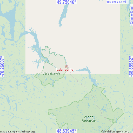
Labrieville GPS coordinates[2]
49° 18' 0.324" North, 69° 33' 46.584" West
| Map corner | latitude | longitude |
|---|---|---|
| Upper-left | 49.75646°, | -70.26607° |
| Center: | 49.30009°, | -69.56294° |
| Lower-right: | 48.83945°, | -68.85982° |
| Map W x H: | 102×102 km | = 63.4×63.4mi |
| max Lat: | 73.03752° ⇑32% North |
| Labrieville: | 49.30009° |
| min Lat: | ⇓68% South 42.05009° |
| min Long | Labrieville | max Long |
| -139.43328° | -69.56294° | -52.70931° |
| W 83.3%⇐ | ⇒16.7% E |
Elevation
Elevation of Labrieville is 156 m = 512 ft, and this is 98.4 m = 323 ft below average elevation for this country.
| Max E: |
1518 m = 4980 ft | 52.7% |
| Avg. | 254.4 m = 835 ft | |
| Labrieville | 156 m = 512 ft | |
Min E: |
-2 m = -7 ft | 47.3% |
See also: Canada elevation on elevation.city.
Geographical zone
Labrieville is located in North temperate zone (between Tropic of Cancer and the Arctic Circle). Distance of this North polar circle is 1919.5 km =1192.7 mi to North.| Distance of | km | miles | from Labrieville |
|---|---|---|---|
| North Pole | 4525.4 | 2812 | to North |
| Arctic Circle | 1919.5 | 1192.7 | to North |
| Tropic Cancer | 2875.7 | 1786.9 | to South |
| Equator | 5481.7 | 3406.2 | to South |


Nearby cities:
15 places around Labrieville: (largest is in red/bold)
• Baie-Comeau
103 km =64 mi,  95°
95°
• Chute-aux-Outardes
87 km =54.1 mi, 103°
• Forestville
71.6 km =44.5 mi,  150°
150°
• Hauterive
95.4 km =59.3 mi, 96°
• Le Bic
120.9 km =75.1 mi, 148°
• Les Escoumins
106 km =65.9 mi,  173°
173°
• Luceville
119.6 km =74.3 mi,  134°
134°
• Mont-Joli
127.9 km =79.5 mi, 128°
• Rimouski
121.4 km =75.4 mi,  141°
141°
• Sacré-Coeur
120.3 km =74.8 mi,  188°
188°
• Saguenay
147.4 km =91.6 mi,  228°
228°
• Saint-Ambroise
153.8 km =95.6 mi,  237°
237°
• Saint-Honoré
140 km =87 mi, 232°
• Saint-Mathieu-de-Rioux
131.2 km =81.5 mi,  161°
161°
• Tadoussac
128.4 km =79.8 mi, 185°
Sources, notices
• [Note1] Compared only with cities in Canada existing in our database
• [Src1] Map data: © OpenStreetMap contributors (CC-BY-SA)
• [Src2] Other city data from geonames.org with taken over terms of usage.
• [Src3] Geographical zone / Annual Mean Temperature by Robert A. Rohde @ Wikipedia
