Matadi geodata
Matadi (Bas-Congo) is a seat of a first-order administrative division; located in Democratic Republic of the Congo in Africa/Kinshasa (GMT+1) time zone. With population of 180,109 people, there are 14 cities with bigger population in this country. Compared to other cities in Democratic Republic of the Congo, 74.3% of cities are located further ↑North; 95.7% of cities are located further →East and 95.7% of cities have higher elevation than Matadi. Note1


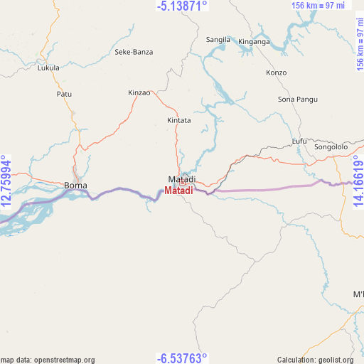
Matadi GPS coordinates[2]
5° 50' 18.996" South, 13° 27' 47.016" East
| Map corner | latitude | longitude |
|---|---|---|
| Upper-left | -5.13871°, | 12.75994° |
| Center: | -5.83861°, | 13.46306° |
| Lower-right: | -6.53763°, | 14.16619° |
| Map W x H: | 155.5×155.5 km | = 96.6×96.6mi |
| max Lat: | 4.279° ⇑74.3% North |
| Matadi: | -5.83861° |
| min Lat: | ⇓25.7% South -11.76097° |
| min Long | Matadi | max Long |
| 12.37148° | 13.46306° | 30.25224° |
| W 4.3%⇐ | ⇒95.7% E |
Elevation
Elevation of Matadi is 183 m = 600 ft, and this is 473 m = 1552 ft below average elevation for this country.
| Max E: |
1996 m = 6549 ft | 95.7% |
| Avg. | 656 m = 2152 ft | |
| Matadi | 183 m = 600 ft | |
Min E: |
11 m = 36 ft | 4.3% |
See also: Matadi elevation on elevation.city.
Geographical zone
Matadi is located in South Torrid zone (between Equator and Tropic of Capricorn). Distance of Equator is 649.2 km =403.4 mi to North.| Distance of | km | miles | from Matadi |
|---|---|---|---|
| Equator | 649.2 | 403.4 | to North |
| Tropic Capricorn | 1956.7 | 1215.8 | to South |
| Antarctic Circle | 6752 | 4195.5 | to South |
| South Pole | 9357.9 | 5814.7 | to South |


Nearby cities:
8 places around Matadi: (largest is in red/bold)
• Boma
45.3 km =28.1 mi,  268°
268°
• Kasangulu
234.6 km =145.8 mi,  53°
53°
• Kasongo-Lunda
377.6 km =234.6 mi,  100°
100°
• Kinshasa
265 km =164.7 mi, 50°
• Masina
267.9 km =166.5 mi, 52°
• Mbanza-Ngungu
167.4 km =104 mi,  67°
67°
• Moanda
121.1 km =75.2 mi, 265°
• Tshela
109.5 km =68 mi,  328°
328°
Sources, notices
• [Note1] Compared only with cities in Democratic Republic of the Congo existing in our database
• [Src1] Map data: © OpenStreetMap contributors (CC-BY-SA)
• [Src2] Other city data from geonames.org with taken over terms of usage.
• [Src3] Geographical zone / Annual Mean Temperature by Robert A. Rohde @ Wikipedia
