Masina geodata
Masina (Kinshasa) is a populated place; located in Democratic Republic of the Congo in Africa/Kinshasa (GMT+1) time zone. With population of 485,167 people, there are 4 cities with bigger population in this country. Compared to other cities in Democratic Republic of the Congo, 55.7% of cities are located further ↑North; 90% of cities are located further →East and 92.9% of cities have higher elevation than Masina. Note1


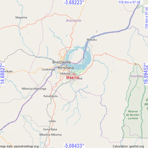
Masina GPS coordinates[2]
4° 23' 0.996" South, 15° 23' 29.004" East
| Map corner | latitude | longitude |
|---|---|---|
| Upper-left | -3.68223°, | 14.68827° |
| Center: | -4.38361°, | 15.39139° |
| Lower-right: | -5.08433°, | 16.09452° |
| Map W x H: | 155.9×155.9 km | = 96.9×96.9mi |
| max Lat: | 4.279° ⇑55.7% North |
| Masina: | -4.38361° |
| min Lat: | ⇓44.3% South -11.76097° |
| min Long | Masina | max Long |
| 12.37148° | 15.39139° | 30.25224° |
| W 10%⇐ | ⇒90% E |
Elevation
Elevation of Masina is 288 m = 945 ft, and this is 368 m = 1207 ft below average elevation for this country.
| Max E: |
1996 m = 6549 ft | 92.9% |
| Avg. | 656 m = 2152 ft | |
| Masina | 288 m = 945 ft | |
Min E: |
11 m = 36 ft | 7.1% |
See also: Masina elevation on elevation.city.
Geographical zone
Masina is located in South Torrid zone (between Equator and Tropic of Capricorn). Distance of Equator is 487.4 km =302.9 mi to North.| Distance of | km | miles | from Masina |
|---|---|---|---|
| Equator | 487.4 | 302.9 | to North |
| Tropic Capricorn | 2118.5 | 1316.4 | to South |
| Antarctic Circle | 6913.8 | 4296 | to South |
| South Pole | 9519.7 | 5915.3 | to South |


Nearby cities:
15 places around Masina: (largest is in red/bold)
• Bandundu
250.5 km =155.7 mi,  61°
61°
• Bolobo
264.5 km =164.4 mi,  20°
20°
• Boma
306 km =190.1 mi,  237°
237°
• Bulungu
356.5 km =221.5 mi,  92°
92°
• Kasangulu
33.5 km =20.8 mi,  228°
228°
• Kasongo-Lunda
281.4 km =174.9 mi,  145°
145°
• Kikwit
386.5 km =240.2 mi,  100°
100°
• Kinshasa
10.6 km =6.6 mi,  305°
305°
• Lukolela
419.6 km =260.7 mi,  28°
28°
• Matadi
267.9 km =166.5 mi, 232°
• Mbanza-Ngungu
113.8 km =70.7 mi,  211°
211°
• Moanda
375.9 km =233.6 mi, 242°
• Mushie
227.9 km =141.6 mi,  48°
48°
• Nioki
315.1 km =195.8 mi, 54°
• Tshela
279.2 km =173.5 mi,  255°
255°
Sources, notices
• [Note1] Compared only with cities in Democratic Republic of the Congo existing in our database
• [Src1] Map data: © OpenStreetMap contributors (CC-BY-SA)
• [Src2] Other city data from geonames.org with taken over terms of usage.
• [Src3] Geographical zone / Annual Mean Temperature by Robert A. Rohde @ Wikipedia
