Mbanza-Ngungu geodata
Mbanza-Ngungu (Bas-Congo) is a populated place; located in Democratic Republic of the Congo in Africa/Kinshasa (GMT+1) time zone. With population of 86,356 people, there are 28 cities with bigger population in this country. Compared to other cities in Democratic Republic of the Congo, 67.1% of cities are located further ↑North; 94.3% of cities are located further →East and 70% of cities have lower elevation than Mbanza-Ngungu. Note1


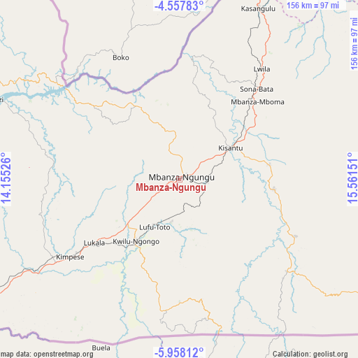
Mbanza-Ngungu GPS coordinates[2]
5° 15' 30.132" South, 14° 51' 30.168" East
| Map corner | latitude | longitude |
|---|---|---|
| Upper-left | -4.55783°, | 14.15526° |
| Center: | -5.25837°, | 14.85838° |
| Lower-right: | -5.95812°, | 15.56151° |
| Map W x H: | 155.7×155.7 km | = 96.7×96.7mi |
| max Lat: | 4.279° ⇑67.1% North |
| Mbanza-Ngungu: | -5.25837° |
| min Lat: | ⇓32.9% South -11.76097° |
| min Long | Mbanza-Ngungu | max Long |
| 12.37148° | 14.85838° | 30.25224° |
| W 5.7%⇐ | ⇒94.3% E |
Elevation
Elevation of Mbanza-Ngungu is 735 m = 2411 ft, and this is 79 m = 259 ft above average elevation for this country.
| Max E: |
1996 m = 6549 ft | 30% |
| Mbanza-Ngungu | 735 m 2411 ft | |
| Avg. | 656 m = 2152 ft | |
Min E: |
11 m = 36 ft | 70% |
See also: Mbanza-Ngungu elevation on elevation.city.
Geographical zone
Mbanza-Ngungu is located in South Torrid zone (between Equator and Tropic of Capricorn). Distance of Equator is 584.7 km =363.3 mi to North.| Distance of | km | miles | from Mbanza-Ngungu |
|---|---|---|---|
| Equator | 584.7 | 363.3 | to North |
| Tropic Capricorn | 2021.2 | 1255.9 | to South |
| Antarctic Circle | 6816.5 | 4235.6 | to South |
| South Pole | 9422.4 | 5854.8 | to South |


Nearby cities:
14 places around Mbanza-Ngungu: (largest is in red/bold)
• Bandundu
353.3 km =219.5 mi,  52°
52°
• Bolobo
376.9 km =234.2 mi,  23°
23°
• Boma
210.3 km =130.7 mi,  251°
251°
• Bulungu
422.4 km =262.5 mi,  79°
79°
• Kasangulu
82.4 km =51.2 mi, 24°
• Kasongo-Lunda
255.6 km =158.8 mi,  122°
122°
• Kikwit
439 km =272.8 mi,  86°
86°
• Kinshasa
115.1 km =71.5 mi,  25°
25°
• Masina
113.8 km =70.7 mi, 31°
• Matadi
167.4 km =104 mi, 247°
• Moanda
285.1 km =177.2 mi, 254°
• Mushie
338.3 km =210.2 mi,  42°
42°
• Nioki
422.2 km =262.3 mi, 48°
• Tshela
213.5 km =132.7 mi,  277°
277°
Sources, notices
• [Note1] Compared only with cities in Democratic Republic of the Congo existing in our database
• [Src1] Map data: © OpenStreetMap contributors (CC-BY-SA)
• [Src2] Other city data from geonames.org with taken over terms of usage.
• [Src3] Geographical zone / Annual Mean Temperature by Robert A. Rohde @ Wikipedia
