Boma geodata
Boma (Bas-Congo) is a populated place; located in Democratic Republic of the Congo in Africa/Kinshasa (GMT+1) time zone. With population of 162,521 people, there are 16 cities with bigger population in this country. Compared to other cities in Democratic Republic of the Congo, 75.7% of cities are located further ↑North; 97.1% of cities are located further →East and 100% of cities have higher elevation than Boma. Note1


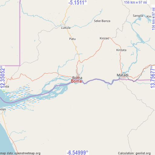
Boma GPS coordinates[2]
5° 51' 3.528" South, 13° 3' 13.104" East
| Map corner | latitude | longitude |
|---|---|---|
| Upper-left | -5.1511°, | 12.35052° |
| Center: | -5.85098°, | 13.05364° |
| Lower-right: | -6.54999°, | 13.75677° |
| Map W x H: | 155.5×155.5 km | = 96.6×96.6mi |
| max Lat: | 4.279° ⇑75.7% North |
| Boma: | -5.85098° |
| min Lat: | ⇓24.3% South -11.76097° |
| min Long | Boma | max Long |
| 12.37148° | 13.05364° | 30.25224° |
| W 2.9%⇐ | ⇒97.1% E |
Elevation
Elevation of Boma is 11 m = 36 ft, and this is 645 m = 2116 ft below average elevation for this country.
| Max E: |
1996 m = 6549 ft | 100% |
| Avg. | 656 m = 2152 ft | |
| Boma | 11 m = 36 ft | |
Min E: |
11 m = 36 ft | 0% |
See also: Boma elevation on elevation.city.
Geographical zone
Boma is located in South Torrid zone (between Equator and Tropic of Capricorn). Distance of Equator is 650.6 km =404.3 mi to North.| Distance of | km | miles | from Boma |
|---|---|---|---|
| Equator | 650.6 | 404.3 | to North |
| Tropic Capricorn | 1955.4 | 1215 | to South |
| Antarctic Circle | 6750.6 | 4194.6 | to South |
| South Pole | 9356.5 | 5813.9 | to South |


Nearby cities:
8 places around Boma: (largest is in red/bold)
• Kasangulu
273 km =169.6 mi,  58°
58°
• Kasongo-Lunda
421.9 km =262.2 mi,  99°
99°
• Kinshasa
302.2 km =187.8 mi, 55°
• Masina
306 km =190.1 mi, 57°
• Matadi
45.3 km =28.1 mi,  88°
88°
• Mbanza-Ngungu
210.3 km =130.7 mi,  71°
71°
• Moanda
75.9 km =47.2 mi,  263°
263°
• Tshela
95.7 km =59.5 mi,  353°
353°
Sources, notices
• [Note1] Compared only with cities in Democratic Republic of the Congo existing in our database
• [Src1] Map data: © OpenStreetMap contributors (CC-BY-SA)
• [Src2] Other city data from geonames.org with taken over terms of usage.
• [Src3] Geographical zone / Annual Mean Temperature by Robert A. Rohde @ Wikipedia
