Kinshasa geodata
Kinshasa is a capital of a political entity; located in Democratic Republic of the Congo in Africa/Kinshasa (GMT+1) time zone. With population of 7,785,965 people, there are 0 cities with bigger population in this country. Compared to other cities in Democratic Republic of the Congo, 52.9% of cities are located further ↑North; 91.4% of cities are located further →East and 94.3% of cities have higher elevation than Kinshasa. Note1


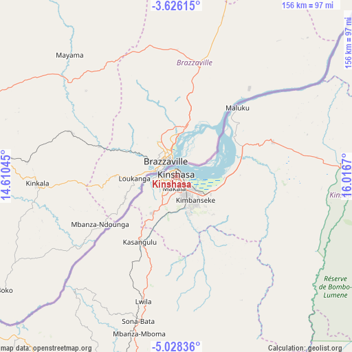
Kinshasa GPS coordinates[2]
4° 19' 39.288" South, 15° 18' 48.852" East
| Map corner | latitude | longitude |
|---|---|---|
| Upper-left | -3.62615°, | 14.61045° |
| Center: | -4.32758°, | 15.31357° |
| Lower-right: | -5.02836°, | 16.0167° |
| Map W x H: | 155.9×155.9 km | = 96.9×96.9mi |
| max Lat: | 4.279° ⇑52.9% North |
| Kinshasa: | -4.32758° |
| min Lat: | ⇓47.1% South -11.76097° |
| min Long | Kinshasa | max Long |
| 12.37148° | 15.31357° | 30.25224° |
| W 8.6%⇐ | ⇒91.4% E |
Elevation
Elevation of Kinshasa is 281 m = 922 ft, and this is 375 m = 1230 ft below average elevation for this country.
| Max E: |
1996 m = 6549 ft | 94.3% |
| Avg. | 656 m = 2152 ft | |
| Kinshasa | 281 m = 922 ft | |
Min E: |
11 m = 36 ft | 5.7% |
See also: Kinshasa elevation on elevation.city.
Geographical zone
Kinshasa is located in South Torrid zone (between Equator and Tropic of Capricorn). Distance of Equator is 481.2 km =299 mi to North.| Distance of | km | miles | from Kinshasa |
|---|---|---|---|
| Equator | 481.2 | 299 | to North |
| Tropic Capricorn | 2124.7 | 1320.2 | to South |
| Antarctic Circle | 6920 | 4299.9 | to South |
| South Pole | 9525.9 | 5919.1 | to South |


Nearby cities:
15 places around Kinshasa: (largest is in red/bold)
• Bandundu
255.4 km =158.7 mi,  63°
63°
• Bolobo
261.9 km =162.7 mi,  22°
22°
• Boma
302.2 km =187.8 mi,  235°
235°
• Bulungu
365.5 km =227.1 mi,  93°
93°
• Kasangulu
32.8 km =20.4 mi,  209°
209°
• Kasongo-Lunda
291.4 km =181.1 mi,  145°
145°
• Kikwit
396.2 km =246.2 mi,  101°
101°
• Lukolela
418.4 km =260 mi,  29°
29°
• Masina
10.6 km =6.6 mi,  125°
125°
• Matadi
265 km =164.7 mi,  230°
230°
• Mbanza-Ngungu
115.1 km =71.5 mi, 205°
• Moanda
371.2 km =230.7 mi, 241°
• Mushie
230.4 km =143.2 mi,  50°
50°
• Nioki
318.6 km =198 mi, 55°
• Tshela
272.5 km =169.3 mi,  254°
254°
Sources, notices
• [Note1] Compared only with cities in Democratic Republic of the Congo existing in our database
• [Src1] Map data: © OpenStreetMap contributors (CC-BY-SA)
• [Src2] Other city data from geonames.org with taken over terms of usage.
• [Src3] Geographical zone / Annual Mean Temperature by Robert A. Rohde @ Wikipedia
