Likasi geodata
Likasi (Haut-Katanga) is a populated place; located in Democratic Republic of the Congo in Africa/Lubumbashi (GMT+2) time zone. With population of 422,414 people, there are 6 cities with bigger population in this country. Compared to other cities in Democratic Republic of the Congo, 97.1% of cities are located further ↑North; 77.1% of cities are located further ←West and 88.6% of cities have lower elevation than Likasi. Note1


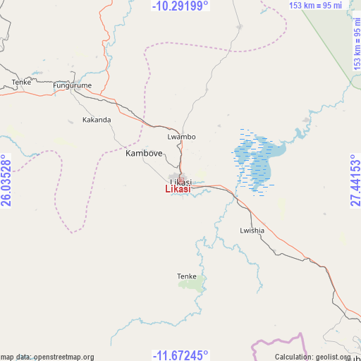
Likasi GPS coordinates[2]
10° 58' 58.908" South, 26° 44' 18.24" East
| Map corner | latitude | longitude |
|---|---|---|
| Upper-left | -10.29199°, | 26.03528° |
| Center: | -10.98303°, | 26.7384° |
| Lower-right: | -11.67245°, | 27.44153° |
| Map W x H: | 153.5×153.5 km | = 95.4×95.4mi |
| max Lat: | 4.279° ⇑97.1% North |
| Likasi: | -10.98303° |
| min Lat: | ⇓2.9% South -11.76097° |
| min Long | Likasi | max Long |
| 12.37148° | 26.7384° | 30.25224° |
| W 77.1%⇐ | ⇒22.9% E |
Elevation
Elevation of Likasi is 1288 m = 4226 ft, and this is 632 m = 2073 ft above average elevation for this country.
| Max E: |
1996 m = 6549 ft | 11.4% |
| Likasi | 1288 m 4226 ft | |
| Avg. | 656 m = 2152 ft | |
Min E: |
11 m = 36 ft | 88.6% |
See also: Likasi elevation on elevation.city.
Geographical zone
Likasi is located in South Torrid zone (between Equator and Tropic of Capricorn). Distance of Equator is 1221.2 km =758.8 mi to North.| Distance of | km | miles | from Likasi |
|---|---|---|---|
| Equator | 1221.2 | 758.8 | to North |
| Tropic Capricorn | 1384.7 | 860.4 | to South |
| Antarctic Circle | 6180 | 3840.1 | to South |
| South Pole | 8785.9 | 5459.3 | to South |


Nearby cities:
6 places around Likasi: (largest is in red/bold)
• Bukama
220.1 km =136.8 mi,  333°
333°
• Kambove
19.6 km =12.2 mi,  308°
308°
• Kamina
314.4 km =195.4 mi,  322°
322°
• Kipushi
103 km =64 mi,  147°
147°
• Kolwezi
142 km =88.2 mi,  282°
282°
• Lubumbashi
110.5 km =68.7 mi,  133°
133°
Sources, notices
• [Note1] Compared only with cities in Democratic Republic of the Congo existing in our database
• [Src1] Map data: © OpenStreetMap contributors (CC-BY-SA)
• [Src2] Other city data from geonames.org with taken over terms of usage.
• [Src3] Geographical zone / Annual Mean Temperature by Robert A. Rohde @ Wikipedia
