Bukama geodata
Bukama (Haut-Lomami) is a populated place; located in Democratic Republic of the Congo in Africa/Lubumbashi (GMT+2) time zone. With population of 38,770 people, there are 46 cities with bigger population in this country. Compared to other cities in Democratic Republic of the Congo, 92.9% of cities are located further ↑North; 70% of cities are located further ←West and 58.6% of cities have lower elevation than Bukama. Note1


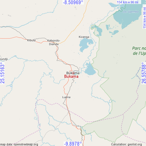
Bukama GPS coordinates[2]
9° 12' 15.948" South, 25° 51' 17.1" East
| Map corner | latitude | longitude |
|---|---|---|
| Upper-left | -8.50969°, | 25.15163° |
| Center: | -9.20443°, | 25.85475° |
| Lower-right: | -9.8978°, | 26.55788° |
| Map W x H: | 154.3×154.3 km | = 95.9×95.9mi |
| max Lat: | 4.279° ⇑92.9% North |
| Bukama: | -9.20443° |
| min Lat: | ⇓7.1% South -11.76097° |
| min Long | Bukama | max Long |
| 12.37148° | 25.85475° | 30.25224° |
| W 70%⇐ | ⇒30% E |
Elevation
Elevation of Bukama is 578 m = 1896 ft, and this is 78 m = 256 ft below average elevation for this country.
| Max E: |
1996 m = 6549 ft | 41.4% |
| Avg. | 656 m = 2152 ft | |
| Bukama | 578 m = 1896 ft | |
Min E: |
11 m = 36 ft | 58.6% |
See also: Democratic Republic of the Congo elevation on elevation.city.
Geographical zone
Bukama is located in South Torrid zone (between Equator and Tropic of Capricorn). Distance of Equator is 1023.4 km =635.9 mi to North.| Distance of | km | miles | from Bukama |
|---|---|---|---|
| Equator | 1023.4 | 635.9 | to North |
| Tropic Capricorn | 1582.5 | 983.3 | to South |
| Antarctic Circle | 6377.7 | 3962.9 | to South |
| South Pole | 8983.6 | 5582.1 | to South |


Nearby cities:
13 places around Bukama: (largest is in red/bold)
• Gandajika
344.4 km =214 mi,  322°
322°
• Kabalo
369.4 km =229.5 mi,  18°
18°
• Kabinda
373 km =231.8 mi,  336°
336°
• Kambove
202.6 km =125.9 mi,  156°
156°
• Kamina
107.6 km =66.9 mi,  299°
299°
• Kipushi
322.7 km =200.5 mi,  151°
151°
• Kolwezi
173.2 km =107.6 mi,  194°
194°
• Kongolo
443 km =275.3 mi, 16°
• Likasi
220.1 km =136.8 mi, 153°
• Lubao
424.5 km =263.8 mi,  358°
358°
• Lubumbashi
325.8 km =202.4 mi, 146°
• Mbuji-Mayi
422.7 km =262.7 mi, 323°
• Mwene-Ditu
359.8 km =223.6 mi,  312°
312°
Sources, notices
• [Note1] Compared only with cities in Democratic Republic of the Congo existing in our database
• [Src1] Map data: © OpenStreetMap contributors (CC-BY-SA)
• [Src2] Other city data from geonames.org with taken over terms of usage.
• [Src3] Geographical zone / Annual Mean Temperature by Robert A. Rohde @ Wikipedia
