Kambove geodata
Kambove (Haut-Katanga) is a populated place; located in Democratic Republic of the Congo in Africa/Lubumbashi (GMT+2) time zone. With population of 36,702 people, there are 50 cities with bigger population in this country. Compared to other cities in Democratic Republic of the Congo, 95.7% of cities are located further ↑North; 72.9% of cities are located further ←West and 91.4% of cities have lower elevation than Kambove. Note1


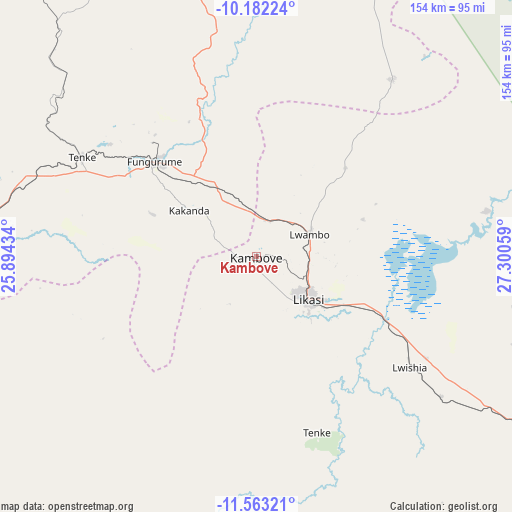
Kambove GPS coordinates[2]
10° 52' 24.672" South, 26° 35' 50.856" East
| Map corner | latitude | longitude |
|---|---|---|
| Upper-left | -10.18224°, | 25.89434° |
| Center: | -10.87352°, | 26.59746° |
| Lower-right: | -11.56321°, | 27.30059° |
| Map W x H: | 153.5×153.6 km | = 95.4×95.4mi |
| max Lat: | 4.279° ⇑95.7% North |
| Kambove: | -10.87352° |
| min Lat: | ⇓4.3% South -11.76097° |
| min Long | Kambove | max Long |
| 12.37148° | 26.59746° | 30.25224° |
| W 72.9%⇐ | ⇒27.1% E |
Elevation
Elevation of Kambove is 1386 m = 4547 ft, and this is 730 m = 2395 ft above average elevation for this country.
| Max E: |
1996 m = 6549 ft | 8.6% |
| Kambove | 1386 m 4547 ft | |
| Avg. | 656 m = 2152 ft | |
Min E: |
11 m = 36 ft | 91.4% |
See also: Democratic Republic of the Congo elevation on elevation.city.
Geographical zone
Kambove is located in South Torrid zone (between Equator and Tropic of Capricorn). Distance of Equator is 1209 km =751.2 mi to North.| Distance of | km | miles | from Kambove |
|---|---|---|---|
| Equator | 1209 | 751.2 | to North |
| Tropic Capricorn | 1396.9 | 868 | to South |
| Antarctic Circle | 6192.2 | 3847.7 | to South |
| South Pole | 8798 | 5466.8 | to South |


Nearby cities:
6 places around Kambove: (largest is in red/bold)
• Bukama
202.6 km =125.9 mi,  336°
336°
• Kamina
295.4 km =183.6 mi,  323°
323°
• Kipushi
121.7 km =75.6 mi,  144°
144°
• Kolwezi
124.8 km =77.5 mi,  278°
278°
• Likasi
19.6 km =12.2 mi,  128°
128°
• Lubumbashi
130.1 km =80.8 mi, 132°
Sources, notices
• [Note1] Compared only with cities in Democratic Republic of the Congo existing in our database
• [Src1] Map data: © OpenStreetMap contributors (CC-BY-SA)
• [Src2] Other city data from geonames.org with taken over terms of usage.
• [Src3] Geographical zone / Annual Mean Temperature by Robert A. Rohde @ Wikipedia
