Kipushi geodata
Kipushi (Haut-Katanga) is a populated place; located in Democratic Republic of the Congo in Africa/Lubumbashi (GMT+2) time zone. With population of 62,332 people, there are 32 cities with bigger population in this country. Compared to other cities in Democratic Republic of the Congo, 100% of cities are located further ↑North; 81.4% of cities are located further ←West and 90% of cities have lower elevation than Kipushi. Note1


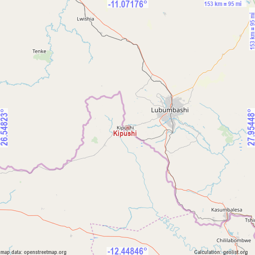
Kipushi GPS coordinates[2]
11° 45' 39.492" South, 27° 15' 4.86" East
| Map corner | latitude | longitude |
|---|---|---|
| Upper-left | -11.07176°, | 26.54823° |
| Center: | -11.76097°, | 27.25135° |
| Lower-right: | -12.44846°, | 27.95448° |
| Map W x H: | 153.1×153.1 km | = 95.1×95.1mi |
| max Lat: | 4.279° ⇑100% North |
| Kipushi: | -11.76097° |
| min Lat: | ⇓0% South -11.76097° |
| min Long | Kipushi | max Long |
| 12.37148° | 27.25135° | 30.25224° |
| W 81.4%⇐ | ⇒18.6% E |
Elevation
Elevation of Kipushi is 1348 m = 4423 ft, and this is 692 m = 2270 ft above average elevation for this country.
| Max E: |
1996 m = 6549 ft | 10% |
| Kipushi | 1348 m 4423 ft | |
| Avg. | 656 m = 2152 ft | |
Min E: |
11 m = 36 ft | 90% |
See also: Kipushi elevation on elevation.city.
Geographical zone
Kipushi is located in South Torrid zone (between Equator and Tropic of Capricorn). Distance of this Southern Tropic circle is 1298.2 km =806.7 mi to South.| Distance of | km | miles | from Kipushi |
|---|---|---|---|
| Equator | 1307.7 | 812.6 | to North |
| Tropic Capricorn | 1298.2 | 806.7 | to South |
| Antarctic Circle | 6093.5 | 3786.3 | to South |
| South Pole | 8699.4 | 5405.6 | to South |


Nearby cities:
6 places around Kipushi: (largest is in red/bold)
• Bukama
322.7 km =200.5 mi,  331°
331°
• Kambove
121.7 km =75.6 mi,  324°
324°
• Kamina
417.1 km =259.2 mi, 323°
• Kolwezi
226.7 km =140.9 mi,  300°
300°
• Likasi
103 km =64 mi, 327°
• Lubumbashi
27.2 km =16.9 mi,  65°
65°
Sources, notices
• [Note1] Compared only with cities in Democratic Republic of the Congo existing in our database
• [Src1] Map data: © OpenStreetMap contributors (CC-BY-SA)
• [Src2] Other city data from geonames.org with taken over terms of usage.
• [Src3] Geographical zone / Annual Mean Temperature by Robert A. Rohde @ Wikipedia
