Wohlen geodata
Wohlen (Bern) is a populated place; located in Switzerland in Europe/Zurich (GMT+2) time zone. With population of 9,159 people, there are 175 cities with bigger population in this country. Compared to other cities in Switzerland, 65.9% of cities are located further ↑North; 78.7% of cities are located further →East and 64.9% of cities have lower elevation than Wohlen. Note1
Administrative division(s):
- Level 1: Bern
- Level 2: Bern-Mittelland District
- Level 3: Wohlen bei Bern


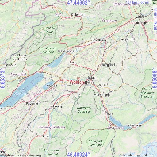
Wohlen GPS coordinates[2]
46° 58' 16.248" North, 7° 21' 24.66" East
| Map corner | latitude | longitude |
|---|---|---|
| Upper-left | 47.44882°, | 6.65373° |
| Center: | 46.97118°, | 7.35685° |
| Lower-right: | 46.48924°, | 8.05998° |
| Map W x H: | 106.7×106.7 km | = 66.3×66.3mi |
| max Lat: | 47.76737° ⇑65.9% North |
| Wohlen: | 46.97118° |
| min Lat: | ⇓34.1% South 45.83203° |
| min Long | Wohlen | max Long |
| 5.97153° | 7.35685° | 10.44624° |
| W 21.3%⇐ | ⇒78.7% E |
Elevation
Elevation of Wohlen is 546 m = 1791 ft, and this is 12.2 m = 40 ft below average elevation for this country.
| Max E: |
1845 m = 6053 ft | 35.1% |
| Avg. | 558.2 m = 1831 ft | |
| Wohlen | 546 m = 1791 ft | |
Min E: |
197 m = 646 ft | 64.9% |
See also: Switzerland elevation on elevation.city.
Geographical zone
Wohlen is located in North temperate zone (between Tropic of Cancer and the Arctic Circle). Distance of this North polar circle is 2178.5 km =1353.7 mi to North.| Distance of | km | miles | from Wohlen |
|---|---|---|---|
| North Pole | 4784.4 | 2972.9 | to North |
| Arctic Circle | 2178.5 | 1353.7 | to North |
| Tropic Cancer | 2616.8 | 1626 | to South |
| Equator | 5222.7 | 3245.2 | to South |


Nearby cities:
15 places around Wohlen: (largest is in red/bold)
• Aarberg
10.2 km =6.3 mi,  322°
322°
• Bern
7.3 km =4.5 mi,  110°
110°
• Bolligen
10.6 km =6.6 mi,  87°
87°
• Flamatt
9.4 km =5.8 mi,  196°
196°
• Frauenkappelen
2.3 km =1.4 mi,  216°
216°
• Grossaffoltern
10.5 km =6.5 mi,  0°
0°
• Kirchlindach
5.6 km =3.5 mi,  55°
55°
• Köniz
6.8 km =4.2 mi,  139°
139°
• Mühleberg
7.5 km =4.7 mi,  255°
255°
• Münchenbuchsee
9.1 km =5.7 mi,  51°
51°
• Ostermundigen
10.2 km =6.3 mi,  98°
98°
• Radelfingen
8.5 km =5.3 mi,  310°
310°
• Schüpfen
7.4 km =4.6 mi,  11°
11°
• Seedorf
7.8 km =4.8 mi,  334°
334°
• Zollikofen
8.3 km =5.2 mi,  68°
68°
Sources, notices
• [Note1] Compared only with cities in Switzerland existing in our database
• [Src1] Map data: © OpenStreetMap contributors (CC-BY-SA)
• [Src2] Other city data from geonames.org with taken over terms of usage.
• [Src3] Geographical zone / Annual Mean Temperature by Robert A. Rohde @ Wikipedia
