Münchenbuchsee geodata
Münchenbuchsee (Bern) is a populated place; located in Switzerland in Europe/Zurich (GMT+2) time zone. With population of 9,801 people, there are 156 cities with bigger population in this country. Compared to other cities in Switzerland, 63.3% of cities are located further ↑North; 76.8% of cities are located further →East and 66.8% of cities have lower elevation than Münchenbuchsee. Note1


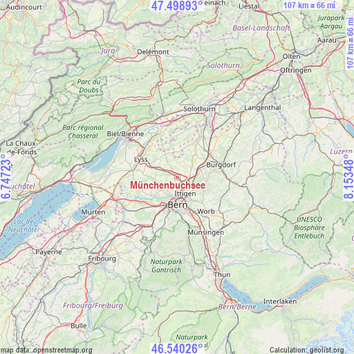
Münchenbuchsee GPS coordinates[2]
47° 1' 18.3" North, 7° 27' 1.296" East
| Map corner | latitude | longitude |
|---|---|---|
| Upper-left | 47.49893°, | 6.74723° |
| Center: | 47.02175°, | 7.45036° |
| Lower-right: | 46.54026°, | 8.15348° |
| Map W x H: | 106.6×106.6 km | = 66.2×66.2mi |
| max Lat: | 47.76737° ⇑63.3% North |
| Münchenbuchsee: | 47.02175° |
| min Lat: | ⇓36.7% South 45.83203° |
| min Long | Münchenbuchsee | max Long |
| 5.97153° | 7.45036° | 10.44624° |
| W 23.2%⇐ | ⇒76.8% E |
Elevation
Elevation of Münchenbuchsee is 556 m = 1824 ft, and this is 2.2 m = 7 ft below average elevation for this country.
| Max E: |
1845 m = 6053 ft | 33.2% |
| Avg. | 558.2 m = 1831 ft | |
| Münchenbuchsee | 556 m = 1824 ft | |
Min E: |
197 m = 646 ft | 66.8% |
See also: Switzerland elevation on elevation.city.
Geographical zone
Münchenbuchsee is located in North temperate zone (between Tropic of Cancer and the Arctic Circle). Distance of this North polar circle is 2172.8 km =1350.1 mi to North.| Distance of | km | miles | from Münchenbuchsee |
|---|---|---|---|
| North Pole | 4778.7 | 2969.3 | to North |
| Arctic Circle | 2172.8 | 1350.1 | to North |
| Tropic Cancer | 2622.4 | 1629.5 | to South |
| Equator | 5228.3 | 3248.7 | to South |


Nearby cities:
15 places around Münchenbuchsee: (largest is in red/bold)
• Bern
8.2 km =5.1 mi,  181°
181°
• Bolligen
6.3 km =3.9 mi,  145°
145°
• Bäriswil
5.8 km =3.6 mi,  92°
92°
• Grossaffoltern
8.6 km =5.3 mi,  304°
304°
• Hindelbank
7.3 km =4.5 mi,  71°
71°
• Jegenstorf
5.2 km =3.2 mi,  56°
56°
• Kirchlindach
3.5 km =2.2 mi,  225°
225°
• Krauchthal
8.9 km =5.5 mi,  98°
98°
• Messen
7.8 km =4.8 mi,  357°
357°
• Ostermundigen
7.8 km =4.8 mi,  157°
157°
• Schüpfen
5.8 km =3.6 mi,  286°
286°
• Stettlen
9 km =5.6 mi,  141°
141°
• Urtenen
3.9 km =2.4 mi,  81°
81°
• Wengi
7.9 km =4.9 mi,  330°
330°
• Zollikofen
2.6 km =1.6 mi,  166°
166°
Sources, notices
• [Note1] Compared only with cities in Switzerland existing in our database
• [Src1] Map data: © OpenStreetMap contributors (CC-BY-SA)
• [Src2] Other city data from geonames.org with taken over terms of usage.
• [Src3] Geographical zone / Annual Mean Temperature by Robert A. Rohde @ Wikipedia
