Werthenstein geodata
Werthenstein (Lucerne) is a populated place; located in Switzerland in Europe/Zurich (GMT+2) time zone. With population of 1,909 people, there are 870 cities with bigger population in this country. Compared to other cities in Switzerland, 61.4% of cities are located further ↑North; 57.8% of cities are located further →East and 65.6% of cities have lower elevation than Werthenstein. Note1


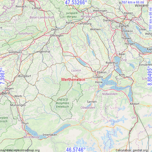
Werthenstein GPS coordinates[2]
47° 3' 20.808" North, 8° 6' 6.552" East
| Map corner | latitude | longitude |
|---|---|---|
| Upper-left | 47.53266°, | 7.3987° |
| Center: | 47.05578°, | 8.10182° |
| Lower-right: | 46.5746°, | 8.80495° |
| Map W x H: | 106.5×106.5 km | = 66.2×66.2mi |
| max Lat: | 47.76737° ⇑61.4% North |
| Werthenstein: | 47.05578° |
| min Lat: | ⇓38.6% South 45.83203° |
| min Long | Werthenstein | max Long |
| 5.97153° | 8.10182° | 10.44624° |
| W 42.2%⇐ | ⇒57.8% E |
Elevation
Elevation of Werthenstein is 549 m = 1801 ft, and this is 9.2 m = 30 ft below average elevation for this country.
| Max E: |
1845 m = 6053 ft | 34.4% |
| Avg. | 558.2 m = 1831 ft | |
| Werthenstein | 549 m = 1801 ft | |
Min E: |
197 m = 646 ft | 65.6% |
See also: Switzerland elevation on elevation.city.
Geographical zone
Werthenstein is located in North temperate zone (between Tropic of Cancer and the Arctic Circle). Distance of this North polar circle is 2169.1 km =1347.8 mi to North.| Distance of | km | miles | from Werthenstein |
|---|---|---|---|
| North Pole | 4774.9 | 2967 | to North |
| Arctic Circle | 2169.1 | 1347.8 | to North |
| Tropic Cancer | 2626.2 | 1631.8 | to South |
| Equator | 5232.1 | 3251.1 | to South |


Nearby cities:
15 places around Werthenstein: (largest is in red/bold)
• Buttisholz
6.5 km =4 mi,  354°
354°
• Doppleschwand
5.5 km =3.4 mi,  220°
220°
• Entlebuch
7.3 km =4.5 mi,  203°
203°
• Grosswangen
9.4 km =5.8 mi,  335°
335°
• Hasle
9.4 km =5.8 mi, 203°
• Malters
6.4 km =4 mi,  109°
109°
• Menznau
5.6 km =3.5 mi,  303°
303°
• Neuenkirch
9.2 km =5.7 mi,  57°
57°
• Nottwil
9.2 km =5.7 mi,  17°
17°
• Oberkirch
11.2 km =7 mi,  5°
5°
• Ruswil
3.7 km =2.3 mi,  30°
30°
• Schwarzenberg
6.9 km =4.3 mi,  128°
128°
• Sempach
11.2 km =7 mi,  37°
37°
• Willisau
11 km =6.8 mi,  312°
312°
• Wolhusen
2.2 km =1.4 mi,  282°
282°
Sources, notices
• [Note1] Compared only with cities in Switzerland existing in our database
• [Src1] Map data: © OpenStreetMap contributors (CC-BY-SA)
• [Src2] Other city data from geonames.org with taken over terms of usage.
• [Src3] Geographical zone / Annual Mean Temperature by Robert A. Rohde @ Wikipedia
