Entlebuch geodata
Entlebuch (Lucerne) is a populated place; located in Switzerland in Europe/Zurich (GMT+2) time zone. With population of 3,293 people, there are 532 cities with bigger population in this country. Compared to other cities in Switzerland, 64.7% of cities are located further ↑North; 58.7% of cities are located further →East and 81.5% of cities have lower elevation than Entlebuch. Note1


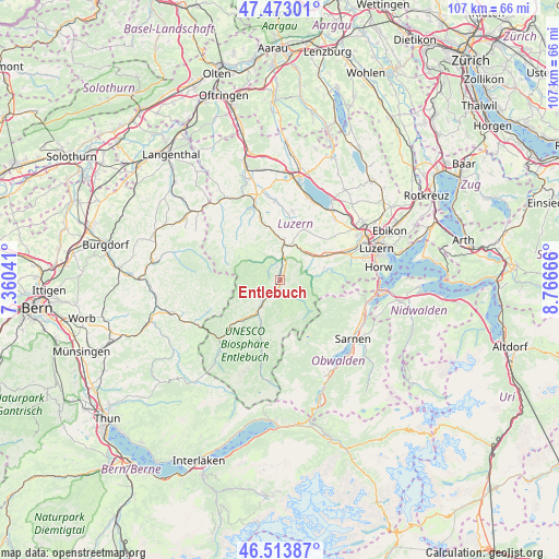
Entlebuch GPS coordinates[2]
46° 59' 44.124" North, 8° 3' 48.744" East
| Map corner | latitude | longitude |
|---|---|---|
| Upper-left | 47.47301°, | 7.36041° |
| Center: | 46.99559°, | 8.06354° |
| Lower-right: | 46.51387°, | 8.76666° |
| Map W x H: | 106.6×106.6 km | = 66.2×66.2mi |
| max Lat: | 47.76737° ⇑64.7% North |
| Entlebuch: | 46.99559° |
| min Lat: | ⇓35.3% South 45.83203° |
| min Long | Entlebuch | max Long |
| 5.97153° | 8.06354° | 10.44624° |
| W 41.3%⇐ | ⇒58.7% E |
Elevation
Elevation of Entlebuch is 682 m = 2238 ft, and this is 123.8 m = 406 ft above average elevation for this country.
| Max E: |
1845 m = 6053 ft | 18.5% |
| Entlebuch | 682 m 2238 ft | |
| Avg. | 558.2 m = 1831 ft | |
Min E: |
197 m = 646 ft | 81.5% |
See also: Switzerland elevation on elevation.city.
Geographical zone
Entlebuch is located in North temperate zone (between Tropic of Cancer and the Arctic Circle). Distance of this North polar circle is 2175.8 km =1352 mi to North.| Distance of | km | miles | from Entlebuch |
|---|---|---|---|
| North Pole | 4781.6 | 2971.1 | to North |
| Arctic Circle | 2175.8 | 1352 | to North |
| Tropic Cancer | 2619.5 | 1627.7 | to South |
| Equator | 5225.4 | 3246.9 | to South |


Nearby cities:
15 places around Entlebuch: (largest is in red/bold)
• Buttisholz
13.4 km =8.3 mi,  9°
9°
• Doppleschwand
2.6 km =1.6 mi,  345°
345°
• Escholzmatt
13.4 km =8.3 mi,  227°
227°
• Flühli
12.9 km =8 mi,  196°
196°
• Hasle
2.1 km =1.3 mi, 201°
• Luthern
13.1 km =8.1 mi,  301°
301°
• Malters
10.1 km =6.3 mi,  63°
63°
• Menznau
10 km =6.2 mi, 349°
• Ruswil
11 km =6.8 mi,  25°
25°
• Schwarzenberg
8.6 km =5.3 mi,  73°
73°
• Schüpfheim
6 km =3.7 mi,  215°
215°
• Trub
15.2 km =9.4 mi,  246°
246°
• Werthenstein
7.3 km =4.5 mi,  23°
23°
• Willisau
15 km =9.3 mi,  339°
339°
• Wolhusen
7.2 km =4.5 mi, 6°
Sources, notices
• [Note1] Compared only with cities in Switzerland existing in our database
• [Src1] Map data: © OpenStreetMap contributors (CC-BY-SA)
• [Src2] Other city data from geonames.org with taken over terms of usage.
• [Src3] Geographical zone / Annual Mean Temperature by Robert A. Rohde @ Wikipedia
