Malters geodata
Malters (Lucerne) is a populated place; located in Switzerland in Europe/Zurich (GMT+2) time zone. With population of 6,181 people, there are 268 cities with bigger population in this country. Compared to other cities in Switzerland, 62.5% of cities are located further ↑North; 55.9% of cities are located further →East and 56.9% of cities have lower elevation than Malters. Note1


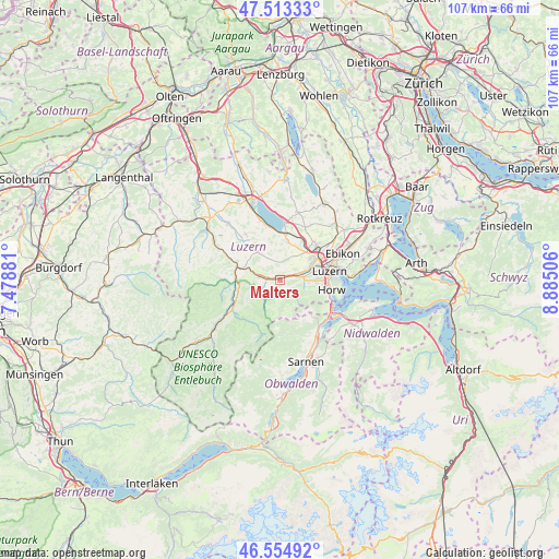
Malters GPS coordinates[2]
47° 2' 10.608" North, 8° 10' 54.948" East
| Map corner | latitude | longitude |
|---|---|---|
| Upper-left | 47.51333°, | 7.47881° |
| Center: | 47.03628°, | 8.18193° |
| Lower-right: | 46.55492°, | 8.88506° |
| Map W x H: | 106.6×106.6 km | = 66.2×66.2mi |
| max Lat: | 47.76737° ⇑62.5% North |
| Malters: | 47.03628° |
| min Lat: | ⇓37.5% South 45.83203° |
| min Long | Malters | max Long |
| 5.97153° | 8.18193° | 10.44624° |
| W 44.1%⇐ | ⇒55.9% E |
Elevation
Elevation of Malters is 504 m = 1654 ft, and this is 54.2 m = 178 ft below average elevation for this country.
| Max E: |
1845 m = 6053 ft | 43.1% |
| Avg. | 558.2 m = 1831 ft | |
| Malters | 504 m = 1654 ft | |
Min E: |
197 m = 646 ft | 56.9% |
See also: Switzerland elevation on elevation.city.
Geographical zone
Malters is located in North temperate zone (between Tropic of Cancer and the Arctic Circle). Distance of this North polar circle is 2171.2 km =1349.1 mi to North.| Distance of | km | miles | from Malters |
|---|---|---|---|
| North Pole | 4777.1 | 2968.4 | to North |
| Arctic Circle | 2171.2 | 1349.1 | to North |
| Tropic Cancer | 2624 | 1630.5 | to South |
| Equator | 5229.9 | 3249.7 | to South |


Nearby cities:
15 places around Malters: (largest is in red/bold)
• Buttisholz
10.9 km =6.8 mi,  322°
322°
• Doppleschwand
9.8 km =6.1 mi,  258°
258°
• Emmen
8.3 km =5.2 mi,  56°
56°
• Entlebuch
10.1 km =6.3 mi,  243°
243°
• Hergiswil
11.3 km =7 mi,  120°
120°
• Horw
9.9 km =6.2 mi,  102°
102°
• Kriens
7.9 km =4.9 mi,  94°
94°
• Littau
6.3 km =3.9 mi,  76°
76°
• Luzern
9.6 km =6 mi, 80°
• Neuenkirch
7.3 km =4.5 mi,  13°
13°
• Ruswil
6.8 km =4.2 mi, 321°
• Schwarzenberg
2.3 km =1.4 mi,  198°
198°
• Sempach
11.1 km =6.9 mi,  3°
3°
• Werthenstein
6.4 km =4 mi,  289°
289°
• Wolhusen
8.6 km =5.3 mi, 287°
Sources, notices
• [Note1] Compared only with cities in Switzerland existing in our database
• [Src1] Map data: © OpenStreetMap contributors (CC-BY-SA)
• [Src2] Other city data from geonames.org with taken over terms of usage.
• [Src3] Geographical zone / Annual Mean Temperature by Robert A. Rohde @ Wikipedia
