Villmergen geodata
Villmergen (Aargau) is a populated place; located in Switzerland in Europe/Zurich (GMT+2) time zone. With population of 5,489 people, there are 306 cities with bigger population in this country. Compared to other cities in Switzerland, 64.8% of cities are located further ↓South; 54.3% of cities are located further →East and 79.7% of cities have higher elevation than Villmergen. Note1


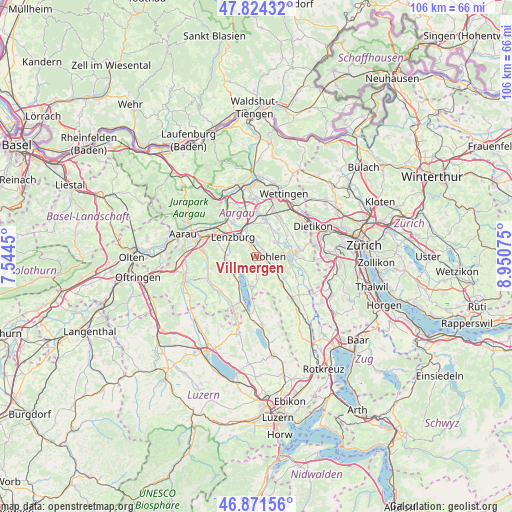
Villmergen GPS coordinates[2]
47° 21' 0.324" North, 8° 14' 51.432" East
| Map corner | latitude | longitude |
|---|---|---|
| Upper-left | 47.82432°, | 7.5445° |
| Center: | 47.35009°, | 8.24762° |
| Lower-right: | 46.87156°, | 8.95075° |
| Map W x H: | 105.9×105.9 km | = 65.8×65.8mi |
| max Lat: | 47.76737° ⇑35.2% North |
| Villmergen: | 47.35009° |
| min Lat: | ⇓64.8% South 45.83203° |
| min Long | Villmergen | max Long |
| 5.97153° | 8.24762° | 10.44624° |
| W 45.7%⇐ | ⇒54.3% E |
Elevation
Elevation of Villmergen is 422 m = 1385 ft, and this is 136.2 m = 447 ft below average elevation for this country.
| Max E: |
1845 m = 6053 ft | 79.7% |
| Avg. | 558.2 m = 1831 ft | |
| Villmergen | 422 m = 1385 ft | |
Min E: |
197 m = 646 ft | 20.3% |
See also: Switzerland elevation on elevation.city.
Geographical zone
Villmergen is located in North temperate zone (between Tropic of Cancer and the Arctic Circle). Distance of this North polar circle is 2136.3 km =1327.4 mi to North.| Distance of | km | miles | from Villmergen |
|---|---|---|---|
| North Pole | 4742.2 | 2946.7 | to North |
| Arctic Circle | 2136.3 | 1327.4 | to North |
| Tropic Cancer | 2658.9 | 1652.2 | to South |
| Equator | 5264.8 | 3271.4 | to South |


Nearby cities:
15 places around Villmergen: (largest is in red/bold)
• Boniswil
5.7 km =3.5 mi,  230°
230°
• Bremgarten
7.1 km =4.4 mi,  89°
89°
• Dottikon
3.9 km =2.4 mi,  351°
351°
• Egliswil
4.7 km =2.9 mi,  268°
268°
• Hendschiken
4.6 km =2.9 mi,  330°
330°
• Hägglingen
4.3 km =2.7 mi,  5°
5°
• Lenzburg
6.9 km =4.3 mi,  308°
308°
• Meisterschwanden
6.3 km =3.9 mi,  193°
193°
• Othmarsingen
6.2 km =3.9 mi,  335°
335°
• Sarmenstorf
4.3 km =2.7 mi,  178°
178°
• Seengen
4.1 km =2.5 mi, 227°
• Seon
6.5 km =4 mi, 268°
• Staufen
7 km =4.3 mi,  300°
300°
• Waltenschwil
4.2 km =2.6 mi,  116°
116°
• Wohlen
2.1 km =1.3 mi, 88°
Sources, notices
• [Note1] Compared only with cities in Switzerland existing in our database
• [Src1] Map data: © OpenStreetMap contributors (CC-BY-SA)
• [Src2] Other city data from geonames.org with taken over terms of usage.
• [Src3] Geographical zone / Annual Mean Temperature by Robert A. Rohde @ Wikipedia
