Waltenschwil geodata
Waltenschwil (Aargau) is a populated place; located in Switzerland in Europe/Zurich (GMT+2) time zone. With population of 2,192 people, there are 780 cities with bigger population in this country. Compared to other cities in Switzerland, 62.7% of cities are located further ↓South; 53.2% of cities are located further →East and 75% of cities have higher elevation than Waltenschwil. Note1


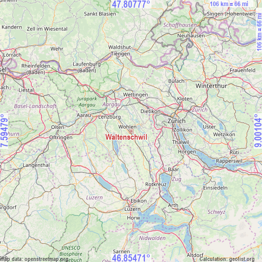
Waltenschwil GPS coordinates[2]
47° 20' 0.204" North, 8° 17' 52.476" East
| Map corner | latitude | longitude |
|---|---|---|
| Upper-left | 47.80777°, | 7.59479° |
| Center: | 47.33339°, | 8.29791° |
| Lower-right: | 46.85471°, | 9.00104° |
| Map W x H: | 106×106 km | = 65.9×65.9mi |
| max Lat: | 47.76737° ⇑37.3% North |
| Waltenschwil: | 47.33339° |
| min Lat: | ⇓62.7% South 45.83203° |
| min Long | Waltenschwil | max Long |
| 5.97153° | 8.29791° | 10.44624° |
| W 46.8%⇐ | ⇒53.2% E |
Elevation
Elevation of Waltenschwil is 431 m = 1414 ft, and this is 127.2 m = 417 ft below average elevation for this country.
| Max E: |
1845 m = 6053 ft | 75% |
| Avg. | 558.2 m = 1831 ft | |
| Waltenschwil | 431 m = 1414 ft | |
Min E: |
197 m = 646 ft | 25% |
See also: Switzerland elevation on elevation.city.
Geographical zone
Waltenschwil is located in North temperate zone (between Tropic of Cancer and the Arctic Circle). Distance of this North polar circle is 2138.2 km =1328.6 mi to North.| Distance of | km | miles | from Waltenschwil |
|---|---|---|---|
| North Pole | 4744.1 | 2947.8 | to North |
| Arctic Circle | 2138.2 | 1328.6 | to North |
| Tropic Cancer | 2657.1 | 1651 | to South |
| Equator | 5263 | 3270.3 | to South |


Nearby cities:
15 places around Waltenschwil: (largest is in red/bold)
• Aristau
7.2 km =4.5 mi,  136°
136°
• Berikon
6 km =3.7 mi,  70°
70°
• Besenbüren
4.2 km =2.6 mi,  120°
120°
• Bremgarten
3.9 km =2.4 mi,  59°
59°
• Bünzen
3.3 km =2.1 mi, 143°
• Dottikon
7.2 km =4.5 mi,  322°
322°
• Hägglingen
7 km =4.3 mi,  331°
331°
• Künten
6.6 km =4.1 mi,  21°
21°
• Meisterschwanden
6.8 km =4.2 mi,  230°
230°
• Rottenschwil
5.3 km =3.3 mi,  114°
114°
• Sarmenstorf
4.4 km =2.7 mi,  235°
235°
• Seengen
6.9 km =4.3 mi,  262°
262°
• Unterlunkhofen
6.4 km =4 mi,  102°
102°
• Villmergen
4.2 km =2.6 mi,  296°
296°
• Wohlen
2.6 km =1.6 mi, 318°
Sources, notices
• [Note1] Compared only with cities in Switzerland existing in our database
• [Src1] Map data: © OpenStreetMap contributors (CC-BY-SA)
• [Src2] Other city data from geonames.org with taken over terms of usage.
• [Src3] Geographical zone / Annual Mean Temperature by Robert A. Rohde @ Wikipedia
