Hendschiken geodata
Hendschiken (Aargau) is a populated place; located in Switzerland in Europe/Zurich (GMT+2) time zone. With population of 930 people, there are 1386 cities with bigger population in this country. Compared to other cities in Switzerland, 70.3% of cities are located further ↓South; 55% of cities are located further →East and 84.6% of cities have higher elevation than Hendschiken. Note1


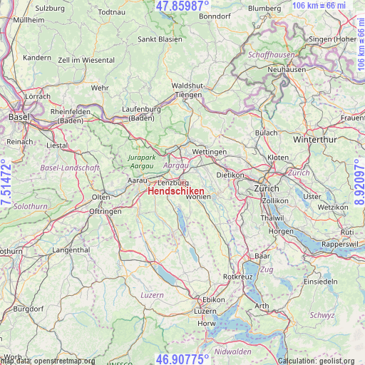
Hendschiken GPS coordinates[2]
47° 23' 9.456" North, 8° 13' 4.26" East
| Map corner | latitude | longitude |
|---|---|---|
| Upper-left | 47.85987°, | 7.51472° |
| Center: | 47.38596°, | 8.21785° |
| Lower-right: | 46.90775°, | 8.92097° |
| Map W x H: | 105.9×105.9 km | = 65.8×65.8mi |
| max Lat: | 47.76737° ⇑29.7% North |
| Hendschiken: | 47.38596° |
| min Lat: | ⇓70.3% South 45.83203° |
| min Long | Hendschiken | max Long |
| 5.97153° | 8.21785° | 10.44624° |
| W 45%⇐ | ⇒55% E |
Elevation
Elevation of Hendschiken is 411 m = 1348 ft, and this is 147.2 m = 483 ft below average elevation for this country.
| Max E: |
1845 m = 6053 ft | 84.6% |
| Avg. | 558.2 m = 1831 ft | |
| Hendschiken | 411 m = 1348 ft | |
Min E: |
197 m = 646 ft | 15.4% |
See also: Switzerland elevation on elevation.city.
Geographical zone
Hendschiken is located in North temperate zone (between Tropic of Cancer and the Arctic Circle). Distance of this North polar circle is 2132.3 km =1324.9 mi to North.| Distance of | km | miles | from Hendschiken |
|---|---|---|---|
| North Pole | 4738.2 | 2944.2 | to North |
| Arctic Circle | 2132.3 | 1324.9 | to North |
| Tropic Cancer | 2662.9 | 1654.6 | to South |
| Equator | 5268.8 | 3273.9 | to South |


Nearby cities:
15 places around Hendschiken: (largest is in red/bold)
• Birr
5.4 km =3.4 mi,  352°
352°
• Dottikon
1.7 km =1.1 mi,  96°
96°
• Egliswil
4.8 km =3 mi,  210°
210°
• Hägglingen
2.7 km =1.7 mi,  83°
83°
• Lenzburg
3.2 km =2 mi,  275°
275°
• Mellingen
5.6 km =3.5 mi,  48°
48°
• Niederlenz
3.5 km =2.2 mi,  297°
297°
• Othmarsingen
1.7 km =1.1 mi, 349°
• Rupperswil
6.9 km =4.3 mi, 284°
• Schafisheim
5.8 km =3.6 mi,  259°
259°
• Seengen
6.8 km =4.2 mi,  186°
186°
• Seon
6 km =3.7 mi,  225°
225°
• Staufen
3.9 km =2.4 mi, 263°
• Villmergen
4.6 km =2.9 mi,  150°
150°
• Wohlen
5.8 km =3.6 mi,  132°
132°
Sources, notices
• [Note1] Compared only with cities in Switzerland existing in our database
• [Src1] Map data: © OpenStreetMap contributors (CC-BY-SA)
• [Src2] Other city data from geonames.org with taken over terms of usage.
• [Src3] Geographical zone / Annual Mean Temperature by Robert A. Rohde @ Wikipedia
