Hägglingen geodata
Hägglingen (Aargau) is a populated place; located in Switzerland in Europe/Zurich (GMT+2) time zone. With population of 2,183 people, there are 784 cities with bigger population in this country. Compared to other cities in Switzerland, 70.7% of cities are located further ↓South; 54.1% of cities are located further →East and 54.2% of cities have higher elevation than Hägglingen. Note1


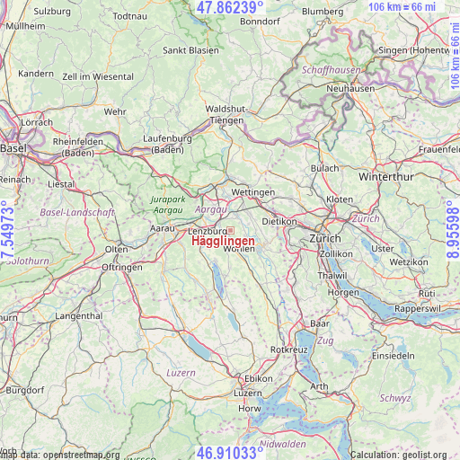
Hägglingen GPS coordinates[2]
47° 23' 18.636" North, 8° 15' 10.26" East
| Map corner | latitude | longitude |
|---|---|---|
| Upper-left | 47.86239°, | 7.54973° |
| Center: | 47.38851°, | 8.25285° |
| Lower-right: | 46.91033°, | 8.95598° |
| Map W x H: | 105.9×105.9 km | = 65.8×65.8mi |
| max Lat: | 47.76737° ⇑29.3% North |
| Hägglingen: | 47.38851° |
| min Lat: | ⇓70.7% South 45.83203° |
| min Long | Hägglingen | max Long |
| 5.97153° | 8.25285° | 10.44624° |
| W 45.9%⇐ | ⇒54.1% E |
Elevation
Elevation of Hägglingen is 469 m = 1539 ft, and this is 89.2 m = 293 ft below average elevation for this country.
| Max E: |
1845 m = 6053 ft | 54.2% |
| Avg. | 558.2 m = 1831 ft | |
| Hägglingen | 469 m = 1539 ft | |
Min E: |
197 m = 646 ft | 45.8% |
See also: Switzerland elevation on elevation.city.
Geographical zone
Hägglingen is located in North temperate zone (between Tropic of Cancer and the Arctic Circle). Distance of this North polar circle is 2132.1 km =1324.8 mi to North.| Distance of | km | miles | from Hägglingen |
|---|---|---|---|
| North Pole | 4738 | 2944.1 | to North |
| Arctic Circle | 2132.1 | 1324.8 | to North |
| Tropic Cancer | 2663.2 | 1654.8 | to South |
| Equator | 5269.1 | 3274.1 | to South |


Nearby cities:
15 places around Hägglingen: (largest is in red/bold)
• Birr
6.1 km =3.8 mi,  327°
327°
• Dottikon
1.1 km =0.7 mi,  244°
244°
• Egliswil
6.7 km =4.2 mi,  229°
229°
• Hendschiken
2.7 km =1.7 mi,  263°
263°
• Künten
5.8 km =3.6 mi,  89°
89°
• Lenzburg
5.9 km =3.7 mi,  270°
270°
• Mellingen
3.7 km =2.3 mi,  24°
24°
• Niederlenz
5.9 km =3.7 mi,  283°
283°
• Niederrohrdorf
5.5 km =3.4 mi,  44°
44°
• Oberrohrdorf
6 km =3.7 mi,  56°
56°
• Othmarsingen
3.3 km =2.1 mi,  295°
295°
• Staufen
6.5 km =4 mi, 263°
• Villmergen
4.3 km =2.7 mi,  185°
185°
• Waltenschwil
7 km =4.3 mi,  151°
151°
• Wohlen
4.5 km =2.8 mi,  158°
158°
Sources, notices
• [Note1] Compared only with cities in Switzerland existing in our database
• [Src1] Map data: © OpenStreetMap contributors (CC-BY-SA)
• [Src2] Other city data from geonames.org with taken over terms of usage.
• [Src3] Geographical zone / Annual Mean Temperature by Robert A. Rohde @ Wikipedia
