Ehrendingen geodata
Ehrendingen (Aargau) is a populated place; located in Switzerland in Europe/Zurich (GMT+2) time zone. With population of 4,519 people, there are 381 cities with bigger population in this country. Compared to other cities in Switzerland, 89.7% of cities are located further ↓South; 52.1% of cities are located further →East and 70.2% of cities have higher elevation than Ehrendingen. Note1


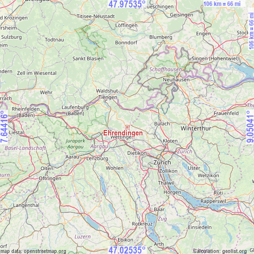
Ehrendingen GPS coordinates[2]
47° 30' 9" North, 8° 20' 50.244" East
| Map corner | latitude | longitude |
|---|---|---|
| Upper-left | 47.97535°, | 7.64416° |
| Center: | 47.5025°, | 8.34729° |
| Lower-right: | 47.02535°, | 9.05041° |
| Map W x H: | 105.6×105.6 km | = 65.6×65.6mi |
| max Lat: | 47.76737° ⇑10.3% North |
| Ehrendingen: | 47.5025° |
| min Lat: | ⇓89.7% South 45.83203° |
| min Long | Ehrendingen | max Long |
| 5.97153° | 8.34729° | 10.44624° |
| W 47.9%⇐ | ⇒52.1% E |
Elevation
Elevation of Ehrendingen is 439 m = 1440 ft, and this is 119.2 m = 391 ft below average elevation for this country.
| Max E: |
1845 m = 6053 ft | 70.2% |
| Avg. | 558.2 m = 1831 ft | |
| Ehrendingen | 439 m = 1440 ft | |
Min E: |
197 m = 646 ft | 29.8% |
See also: Switzerland elevation on elevation.city.
Geographical zone
Ehrendingen is located in North temperate zone (between Tropic of Cancer and the Arctic Circle). Distance of this North polar circle is 2119.4 km =1316.9 mi to North.| Distance of | km | miles | from Ehrendingen |
|---|---|---|---|
| North Pole | 4725.3 | 2936.2 | to North |
| Arctic Circle | 2119.4 | 1316.9 | to North |
| Tropic Cancer | 2675.9 | 1662.7 | to South |
| Equator | 5281.8 | 3282 | to South |


Nearby cities:
15 places around Ehrendingen: (largest is in red/bold)
• Baden
4.5 km =2.8 mi,  223°
223°
• Boppelsen
5.7 km =3.5 mi,  129°
129°
• Dänikon
7.6 km =4.7 mi,  144°
144°
• Endingen
5.8 km =3.6 mi,  312°
312°
• Neuenhof
6.1 km =3.8 mi,  194°
194°
• Niederweningen / Niederweningen (Dorf)
2.3 km =1.4 mi,  79°
79°
• Obersiggenthal
4.2 km =2.6 mi,  246°
246°
• Oberweningen
4.5 km =2.8 mi,  90°
90°
• Otelfingen
5.7 km =3.5 mi, 144°
• Siglistorf
5.3 km =3.3 mi,  27°
27°
• Turgi
7.1 km =4.4 mi,  260°
260°
• Untersiggenthal
6.9 km =4.3 mi,  269°
269°
• Wettingen
4.3 km =2.7 mi,  213°
213°
• Würenlingen
7.6 km =4.7 mi,  296°
296°
• Würenlos
6.8 km =4.2 mi,  170°
170°
Sources, notices
• [Note1] Compared only with cities in Switzerland existing in our database
• [Src1] Map data: © OpenStreetMap contributors (CC-BY-SA)
• [Src2] Other city data from geonames.org with taken over terms of usage.
• [Src3] Geographical zone / Annual Mean Temperature by Robert A. Rohde @ Wikipedia
