Tiefencastel geodata
Tiefencastel (Grisons) is a seat of a second-order administrative division; located in Switzerland in Europe/Zurich (GMT+2) time zone. With population of 244 people, there are 1816 cities with bigger population in this country. Compared to other cities in Switzerland, 80% of cities are located further ↑North; 98% of cities are located further ←West and 92.3% of cities have lower elevation than Tiefencastel. Note1


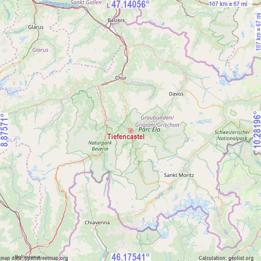
Tiefencastel GPS coordinates[2]
46° 39' 36.504" North, 9° 34' 43.788" East
| Map corner | latitude | longitude |
|---|---|---|
| Upper-left | 47.14056°, | 8.87571° |
| Center: | 46.66014°, | 9.57883° |
| Lower-right: | 46.17541°, | 10.28196° |
| Map W x H: | 107.3×107.3 km | = 66.7×66.7mi |
| max Lat: | 47.76737° ⇑80% North |
| Tiefencastel: | 46.66014° |
| min Lat: | ⇓20% South 45.83203° |
| min Long | Tiefencastel | max Long |
| 5.97153° | 9.57883° | 10.44624° |
| W 98%⇐ | ⇒2% E |
Elevation
Elevation of Tiefencastel is 891 m = 2923 ft, and this is 332.8 m = 1092 ft above average elevation for this country.
| Max E: |
1845 m = 6053 ft | 7.7% |
| Tiefencastel | 891 m 2923 ft | |
| Avg. | 558.2 m = 1831 ft | |
Min E: |
197 m = 646 ft | 92.3% |
See also: Switzerland elevation on elevation.city.
Geographical zone
Tiefencastel is located in North temperate zone (between Tropic of Cancer and the Arctic Circle). Distance of this North polar circle is 2213.1 km =1375.2 mi to North.| Distance of | km | miles | from Tiefencastel |
|---|---|---|---|
| North Pole | 4818.9 | 2994.3 | to North |
| Arctic Circle | 2213.1 | 1375.2 | to North |
| Tropic Cancer | 2582.2 | 1604.5 | to South |
| Equator | 5188.1 | 3223.7 | to South |


Nearby cities:
15 places around Tiefencastel: (largest is in red/bold)
• Andeer
13.3 km =8.3 mi,  241°
241°
• Arosa
15.1 km =9.4 mi,  29°
29°
• Bergün
13.3 km =8.3 mi,  104°
104°
• Cazis
12.9 km =8 mi,  300°
300°
• Chur
21.4 km =13.3 mi,  350°
350°
• Churwalden
13.7 km =8.5 mi, 348°
• Donat
11.9 km =7.4 mi,  252°
252°
• Filisur
8.3 km =5.2 mi,  80°
80°
• Lenzerheide
7.1 km =4.4 mi, 347°
• Malix
17.3 km =10.7 mi, 348°
• Rhäzüns
20.7 km =12.9 mi,  318°
318°
• Savognin
7.1 km =4.4 mi,  168°
168°
• Scharans
11.2 km =7 mi,  305°
305°
• Sils im Domleschg
10.5 km =6.5 mi, 295°
• Thusis
11.4 km =7.1 mi,  291°
291°
Sources, notices
• [Note1] Compared only with cities in Switzerland existing in our database
• [Src1] Map data: © OpenStreetMap contributors (CC-BY-SA)
• [Src2] Other city data from geonames.org with taken over terms of usage.
• [Src3] Geographical zone / Annual Mean Temperature by Robert A. Rohde @ Wikipedia
