Churwalden geodata
Churwalden (Grisons) is a populated place; located in Switzerland in Europe/Zurich (GMT+2) time zone. With population of 1,214 people, there are 1189 cities with bigger population in this country. Compared to other cities in Switzerland, 75.5% of cities are located further ↑North; 97.2% of cities are located further ←West and 97.6% of cities have lower elevation than Churwalden. Note1


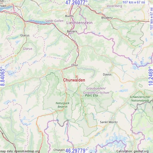
Churwalden GPS coordinates[2]
46° 46' 53.148" North, 9° 32' 37.572" East
| Map corner | latitude | longitude |
|---|---|---|
| Upper-left | 47.26077°, | 8.84065° |
| Center: | 46.78143°, | 9.54377° |
| Lower-right: | 46.29779°, | 10.2469° |
| Map W x H: | 107.1×107.1 km | = 66.5×66.5mi |
| max Lat: | 47.76737° ⇑75.5% North |
| Churwalden: | 46.78143° |
| min Lat: | ⇓24.5% South 45.83203° |
| min Long | Churwalden | max Long |
| 5.97153° | 9.54377° | 10.44624° |
| W 97.2%⇐ | ⇒2.8% E |
Elevation
Elevation of Churwalden is 1252 m = 4108 ft, and this is 693.8 m = 2276 ft above average elevation for this country.
| Max E: |
1845 m = 6053 ft | 2.4% |
| Churwalden | 1252 m 4108 ft | |
| Avg. | 558.2 m = 1831 ft | |
Min E: |
197 m = 646 ft | 97.6% |
See also: Switzerland elevation on elevation.city.
Geographical zone
Churwalden is located in North temperate zone (between Tropic of Cancer and the Arctic Circle). Distance of this North polar circle is 2199.6 km =1366.8 mi to North.| Distance of | km | miles | from Churwalden |
|---|---|---|---|
| North Pole | 4805.5 | 2986 | to North |
| Arctic Circle | 2199.6 | 1366.8 | to North |
| Tropic Cancer | 2595.7 | 1612.9 | to South |
| Equator | 5201.6 | 3232.1 | to South |


Nearby cities:
15 places around Churwalden: (largest is in red/bold)
• Arosa
10.1 km =6.3 mi,  92°
92°
• Bonaduz
11.6 km =7.2 mi,  286°
286°
• Cazis
10.9 km =6.8 mi,  230°
230°
• Chur
7.7 km =4.8 mi,  353°
353°
• Domat
9.2 km =5.7 mi,  309°
309°
• Felsberg
8.8 km =5.5 mi,  324°
324°
• Haldenstein
10.9 km =6.8 mi, 352°
• Lenzerheide
6.7 km =4.2 mi,  169°
169°
• Malix
3.6 km =2.2 mi, 345°
• Rhäzüns
11.3 km =7 mi,  279°
279°
• Scharans
9.5 km =5.9 mi,  222°
222°
• Sils im Domleschg
11.3 km =7 mi, 217°
• Tamins
11.7 km =7.3 mi,  297°
297°
• Thusis
12.3 km =7.6 mi, 220°
• Trimmis
13.3 km =8.3 mi,  5°
5°
Sources, notices
• [Note1] Compared only with cities in Switzerland existing in our database
• [Src1] Map data: © OpenStreetMap contributors (CC-BY-SA)
• [Src2] Other city data from geonames.org with taken over terms of usage.
• [Src3] Geographical zone / Annual Mean Temperature by Robert A. Rohde @ Wikipedia
