Chur geodata
Chur (Grisons) is a seat of a first-order administrative division; located in Switzerland in Europe/Zurich (GMT+2) time zone. With population of 32,429 people, there are 21 cities with bigger population in this country. Compared to other cities in Switzerland, 71.9% of cities are located further ↑North; 97% of cities are located further ←West and 73.5% of cities have lower elevation than Chur. Note1


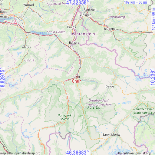
Chur GPS coordinates[2]
46° 50' 59.496" North, 9° 31' 58.332" East
| Map corner | latitude | longitude |
|---|---|---|
| Upper-left | 47.32858°, | 8.82975° |
| Center: | 46.84986°, | 9.53287° |
| Lower-right: | 46.36683°, | 10.236° |
| Map W x H: | 106.9×106.9 km | = 66.4×66.4mi |
| max Lat: | 47.76737° ⇑71.9% North |
| Chur: | 46.84986° |
| min Lat: | ⇓28.1% South 45.83203° |
| min Long | Chur | max Long |
| 5.97153° | 9.53287° | 10.44624° |
| W 97%⇐ | ⇒3% E |
Elevation
Elevation of Chur is 601 m = 1972 ft, and this is 42.8 m = 140 ft above average elevation for this country.
| Max E: |
1845 m = 6053 ft | 26.5% |
| Chur | 601 m 1972 ft | |
| Avg. | 558.2 m = 1831 ft | |
Min E: |
197 m = 646 ft | 73.5% |
See also: Switzerland elevation on elevation.city.
Geographical zone
Chur is located in North temperate zone (between Tropic of Cancer and the Arctic Circle). Distance of this North polar circle is 2192 km =1362 mi to North.| Distance of | km | miles | from Chur |
|---|---|---|---|
| North Pole | 4797.8 | 2981.2 | to North |
| Arctic Circle | 2192 | 1362 | to North |
| Tropic Cancer | 2603.3 | 1617.6 | to South |
| Equator | 5209.2 | 3236.8 | to South |


Nearby cities:
15 places around Chur: (largest is in red/bold)
• Arosa
13.5 km =8.4 mi,  126°
126°
• Bonaduz
11.1 km =6.9 mi,  247°
247°
• Churwalden
7.7 km =4.8 mi,  173°
173°
• Domat
6.5 km =4 mi,  255°
255°
• Felsberg
4.4 km =2.7 mi, 263°
• Haldenstein
3.2 km =2 mi,  350°
350°
• Igis
11 km =6.8 mi,  15°
15°
• Landquart
11.4 km =7.1 mi,  12°
12°
• Malix
4.2 km =2.6 mi,  180°
180°
• Mastrils
13.4 km =8.3 mi,  3°
3°
• Rhäzüns
11.7 km =7.3 mi,  241°
241°
• Tamins
9.9 km =6.2 mi, 256°
• Trimmis
6.1 km =3.8 mi, 20°
• Untervaz
8.6 km =5.3 mi, 0°
• Zizers
9.9 km =6.2 mi, 14°
In other languages:
- In Spanish: Coira
- In France: Coire
- In Italian: Coira
- In Russian: Кур
- In Chinese: 庫爾
Sources, notices
• [Note1] Compared only with cities in Switzerland existing in our database
• [Src1] Map data: © OpenStreetMap contributors (CC-BY-SA)
• [Src2] Other city data from geonames.org with taken over terms of usage.
• [Src3] Geographical zone / Annual Mean Temperature by Robert A. Rohde @ Wikipedia
