Filisur geodata
Filisur (Grisons) is a populated place; located in Switzerland in Europe/Zurich (GMT+2) time zone. With population of 502 people, there are 1806 cities with bigger population in this country. Compared to other cities in Switzerland, 79.4% of cities are located further ↑North; 98.7% of cities are located further ←West and 95.4% of cities have lower elevation than Filisur. Note1


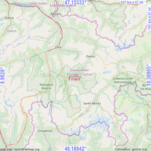
Filisur GPS coordinates[2]
46° 40' 22.908" North, 9° 41' 9.312" East
| Map corner | latitude | longitude |
|---|---|---|
| Upper-left | 47.15333°, | 8.9828° |
| Center: | 46.67303°, | 9.68592° |
| Lower-right: | 46.18842°, | 10.38905° |
| Map W x H: | 107.3×107.3 km | = 66.7×66.7mi |
| max Lat: | 47.76737° ⇑79.4% North |
| Filisur: | 46.67303° |
| min Lat: | ⇓20.6% South 45.83203° |
| min Long | Filisur | max Long |
| 5.97153° | 9.68592° | 10.44624° |
| W 98.7%⇐ | ⇒1.3% E |
Elevation
Elevation of Filisur is 1026 m = 3366 ft, and this is 467.8 m = 1535 ft above average elevation for this country.
| Max E: |
1845 m = 6053 ft | 4.6% |
| Filisur | 1026 m 3366 ft | |
| Avg. | 558.2 m = 1831 ft | |
Min E: |
197 m = 646 ft | 95.4% |
See also: Switzerland elevation on elevation.city.
Geographical zone
Filisur is located in North temperate zone (between Tropic of Cancer and the Arctic Circle). Distance of this North polar circle is 2211.6 km =1374.2 mi to North.| Distance of | km | miles | from Filisur |
|---|---|---|---|
| North Pole | 4817.5 | 2993.5 | to North |
| Arctic Circle | 2211.6 | 1374.2 | to North |
| Tropic Cancer | 2583.6 | 1605.4 | to South |
| Equator | 5189.6 | 3224.7 | to South |


Nearby cities:
15 places around Filisur: (largest is in red/bold)
• Arosa
11.7 km =7.3 mi,  356°
356°
• Bergün
6.8 km =4.2 mi,  135°
135°
• Cazis
20 km =12.4 mi,  284°
284°
• Churwalden
16.2 km =10.1 mi,  318°
318°
• Davos
18.6 km =11.6 mi,  38°
38°
• Donat
20.2 km =12.6 mi,  255°
255°
• La Punt Chamues-ch
20.7 km =12.9 mi,  120°
120°
• Lenzerheide
11.1 km =6.9 mi,  299°
299°
• Malix
19.4 km =12.1 mi, 322°
• Samedan
21 km =13 mi, 137°
• Savognin
10.8 km =6.7 mi,  218°
218°
• Scharans
18 km =11.2 mi,  286°
286°
• Sils im Domleschg
17.9 km =11.1 mi, 279°
• Thusis
19 km =11.8 mi, 278°
• Tiefencastel
8.3 km =5.2 mi, 260°
Sources, notices
• [Note1] Compared only with cities in Switzerland existing in our database
• [Src1] Map data: © OpenStreetMap contributors (CC-BY-SA)
• [Src2] Other city data from geonames.org with taken over terms of usage.
• [Src3] Geographical zone / Annual Mean Temperature by Robert A. Rohde @ Wikipedia
