Sils im Domleschg geodata
Sils im Domleschg (Grisons) is a populated place; located in Switzerland in Europe/Zurich (GMT+2) time zone. With population of 834 people, there are 1471 cities with bigger population in this country. Compared to other cities in Switzerland, 78.3% of cities are located further ↑North; 96% of cities are located further ←West and 81.6% of cities have lower elevation than Sils im Domleschg. Note1


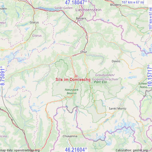
Sils im Domleschg GPS coordinates[2]
46° 42' 1.476" North, 9° 27' 14.544" East
| Map corner | latitude | longitude |
|---|---|---|
| Upper-left | 47.18047°, | 8.75091° |
| Center: | 46.70041°, | 9.45404° |
| Lower-right: | 46.21604°, | 10.15717° |
| Map W x H: | 107.2×107.2 km | = 66.6×66.6mi |
| max Lat: | 47.76737° ⇑78.3% North |
| Sils im Domleschg: | 46.70041° |
| min Lat: | ⇓21.7% South 45.83203° |
| min Long | Sils im Domlesc | max Long |
| 5.97153° | 9.45404° | 10.44624° |
| W 96%⇐ | ⇒4% E |
Elevation
Elevation of Sils im Domleschg is 684 m = 2244 ft, and this is 125.8 m = 413 ft above average elevation for this country.
| Max E: |
1845 m = 6053 ft | 18.4% |
| Sils im Domleschg | 684 m 2244 ft | |
| Avg. | 558.2 m = 1831 ft | |
Min E: |
197 m = 646 ft | 81.6% |
See also: Switzerland elevation on elevation.city.
Geographical zone
Sils im Domleschg is located in North temperate zone (between Tropic of Cancer and the Arctic Circle). Distance of this North polar circle is 2208.6 km =1372.4 mi to North.| Distance of | km | miles | from Sils im Domleschg |
|---|---|---|---|
| North Pole | 4814.5 | 2991.6 | to North |
| Arctic Circle | 2208.6 | 1372.4 | to North |
| Tropic Cancer | 2586.7 | 1607.3 | to South |
| Equator | 5192.6 | 3226.5 | to South |


Nearby cities:
15 places around Sils im Domleschg: (largest is in red/bold)
• Andeer
11 km =6.8 mi,  191°
191°
• Bonaduz
13 km =8.1 mi,  340°
340°
• Cazis
2.7 km =1.7 mi,  322°
322°
• Churwalden
11.3 km =7 mi,  37°
37°
• Domat
14.9 km =9.3 mi,  359°
359°
• Donat
8.2 km =5.1 mi, 193°
• Felsberg
16.2 km =10.1 mi,  5°
5°
• Lenzerheide
8.4 km =5.2 mi,  73°
73°
• Malix
13.8 km =8.6 mi,  25°
25°
• Rhäzüns
11.8 km =7.3 mi, 338°
• Savognin
15.9 km =9.9 mi,  136°
136°
• Scharans
2 km =1.2 mi, 10°
• Tamins
14.8 km =9.2 mi,  345°
345°
• Thusis
1.2 km =0.7 mi,  252°
252°
• Tiefencastel
10.5 km =6.5 mi,  115°
115°
Sources, notices
• [Note1] Compared only with cities in Switzerland existing in our database
• [Src1] Map data: © OpenStreetMap contributors (CC-BY-SA)
• [Src2] Other city data from geonames.org with taken over terms of usage.
• [Src3] Geographical zone / Annual Mean Temperature by Robert A. Rohde @ Wikipedia
