Tamins geodata
Tamins (Grisons) is a populated place; located in Switzerland in Europe/Zurich (GMT+2) time zone. With population of 1,160 people, there are 1224 cities with bigger population in this country. Compared to other cities in Switzerland, 72.8% of cities are located further ↑North; 95.2% of cities are located further ←West and 80.6% of cities have lower elevation than Tamins. Note1


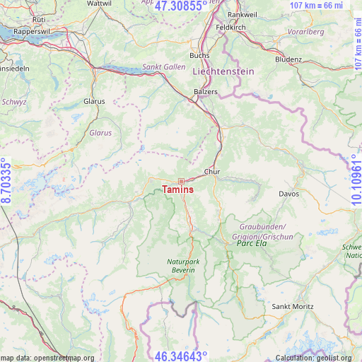
Tamins GPS coordinates[2]
46° 49' 46.704" North, 9° 24' 23.328" East
| Map corner | latitude | longitude |
|---|---|---|
| Upper-left | 47.30855°, | 8.70335° |
| Center: | 46.82964°, | 9.40648° |
| Lower-right: | 46.34643°, | 10.10961° |
| Map W x H: | 107×107 km | = 66.5×66.5mi |
| max Lat: | 47.76737° ⇑72.8% North |
| Tamins: | 46.82964° |
| min Lat: | ⇓27.2% South 45.83203° |
| min Long | Tamins | max Long |
| 5.97153° | 9.40648° | 10.44624° |
| W 95.2%⇐ | ⇒4.8% E |
Elevation
Elevation of Tamins is 667 m = 2188 ft, and this is 108.8 m = 357 ft above average elevation for this country.
| Max E: |
1845 m = 6053 ft | 19.4% |
| Tamins | 667 m 2188 ft | |
| Avg. | 558.2 m = 1831 ft | |
Min E: |
197 m = 646 ft | 80.6% |
See also: Switzerland elevation on elevation.city.
Geographical zone
Tamins is located in North temperate zone (between Tropic of Cancer and the Arctic Circle). Distance of this North polar circle is 2194.2 km =1363.4 mi to North.| Distance of | km | miles | from Tamins |
|---|---|---|---|
| North Pole | 4800.1 | 2982.6 | to North |
| Arctic Circle | 2194.2 | 1363.4 | to North |
| Tropic Cancer | 2601 | 1616.2 | to South |
| Equator | 5207 | 3235.5 | to South |


Nearby cities:
15 places around Tamins: (largest is in red/bold)
• Bonaduz
2.2 km =1.4 mi,  196°
196°
• Cazis
12.4 km =7.7 mi,  170°
170°
• Chur
9.9 km =6.2 mi,  76°
76°
• Churwalden
11.7 km =7.3 mi,  117°
117°
• Domat
3.4 km =2.1 mi, 80°
• Falera
13.7 km =8.5 mi,  256°
256°
• Felsberg
5.6 km =3.5 mi,  71°
71°
• Flims
9.3 km =5.8 mi,  275°
275°
• Haldenstein
10.6 km =6.6 mi,  59°
59°
• Laax
11.6 km =7.2 mi, 256°
• Malix
9.7 km =6 mi,  101°
101°
• Rhäzüns
3.5 km =2.2 mi,  191°
191°
• Scharans
13 km =8.1 mi,  162°
162°
• Trimmis
14.2 km =8.8 mi, 56°
• Untervaz
14.6 km =9.1 mi,  41°
41°
Sources, notices
• [Note1] Compared only with cities in Switzerland existing in our database
• [Src1] Map data: © OpenStreetMap contributors (CC-BY-SA)
• [Src2] Other city data from geonames.org with taken over terms of usage.
• [Src3] Geographical zone / Annual Mean Temperature by Robert A. Rohde @ Wikipedia
