Wengi geodata
Wengi (Bern) is a populated place; located in Switzerland in Europe/Zurich (GMT+2) time zone. With population of 579 people, there are 1715 cities with bigger population in this country. Compared to other cities in Switzerland, 59.8% of cities are located further ↑North; 77.8% of cities are located further →East and 51.4% of cities have lower elevation than Wengi. Note1


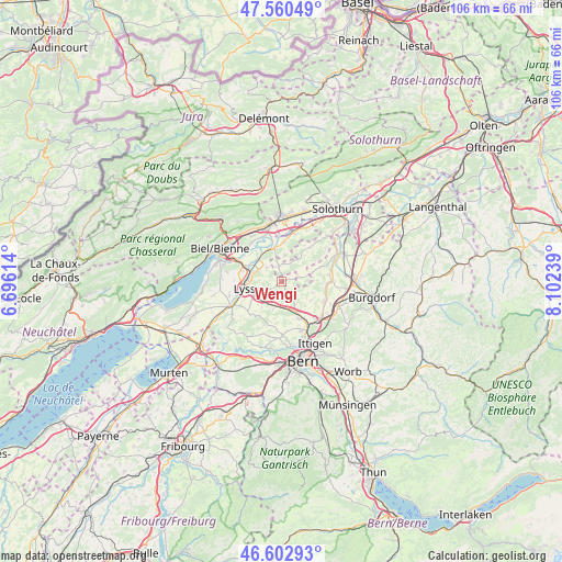
Wengi GPS coordinates[2]
47° 5' 1.896" North, 7° 23' 57.336" East
| Map corner | latitude | longitude |
|---|---|---|
| Upper-left | 47.56049°, | 6.69614° |
| Center: | 47.08386°, | 7.39926° |
| Lower-right: | 46.60293°, | 8.10239° |
| Map W x H: | 106.5×106.5 km | = 66.2×66.2mi |
| max Lat: | 47.76737° ⇑59.8% North |
| Wengi: | 47.08386° |
| min Lat: | ⇓40.2% South 45.83203° |
| min Long | Wengi | max Long |
| 5.97153° | 7.39926° | 10.44624° |
| W 22.2%⇐ | ⇒77.8% E |
Elevation
Elevation of Wengi is 481 m = 1578 ft, and this is 77.2 m = 253 ft below average elevation for this country.
| Max E: |
1845 m = 6053 ft | 48.6% |
| Avg. | 558.2 m = 1831 ft | |
| Wengi | 481 m = 1578 ft | |
Min E: |
197 m = 646 ft | 51.4% |
See also: Switzerland elevation on elevation.city.
Geographical zone
Wengi is located in North temperate zone (between Tropic of Cancer and the Arctic Circle). Distance of this North polar circle is 2165.9 km =1345.8 mi to North.| Distance of | km | miles | from Wengi |
|---|---|---|---|
| North Pole | 4771.8 | 2965.1 | to North |
| Arctic Circle | 2165.9 | 1345.8 | to North |
| Tropic Cancer | 2629.3 | 1633.8 | to South |
| Equator | 5235.2 | 3253 | to South |


Nearby cities:
15 places around Wengi: (largest is in red/bold)
• Arch
9.4 km =5.8 mi,  15°
15°
• Büren an der Aare
6.6 km =4.1 mi,  341°
341°
• Fraubrunnen
9.7 km =6 mi,  88°
88°
• Grossaffoltern
3.8 km =2.4 mi,  237°
237°
• Jegenstorf
9.1 km =5.7 mi,  115°
115°
• Kirchlindach
9.5 km =5.9 mi,  171°
171°
• Lyss
7.1 km =4.4 mi,  261°
261°
• Meinisberg
9.3 km =5.8 mi, 335°
• Messen
3.6 km =2.2 mi,  76°
76°
• Münchenbuchsee
7.9 km =4.9 mi,  150°
150°
• Orpund
9.2 km =5.7 mi,  311°
311°
• Schnottwil
3.1 km =1.9 mi,  352°
352°
• Schüpfen
5.5 km =3.4 mi,  197°
197°
• Seedorf
8.6 km =5.3 mi,  230°
230°
• Worben
8.2 km =5.1 mi,  284°
284°
Sources, notices
• [Note1] Compared only with cities in Switzerland existing in our database
• [Src1] Map data: © OpenStreetMap contributors (CC-BY-SA)
• [Src2] Other city data from geonames.org with taken over terms of usage.
• [Src3] Geographical zone / Annual Mean Temperature by Robert A. Rohde @ Wikipedia
