Satigny geodata
Satigny (Geneva) is a populated place; located in Switzerland in Europe/Zurich (GMT+2) time zone. With population of 3,055 people, there are 580 cities with bigger population in this country. Compared to other cities in Switzerland, 93.9% of cities are located further ↑North; 99.8% of cities are located further →East and 79.7% of cities have higher elevation than Satigny. Note1


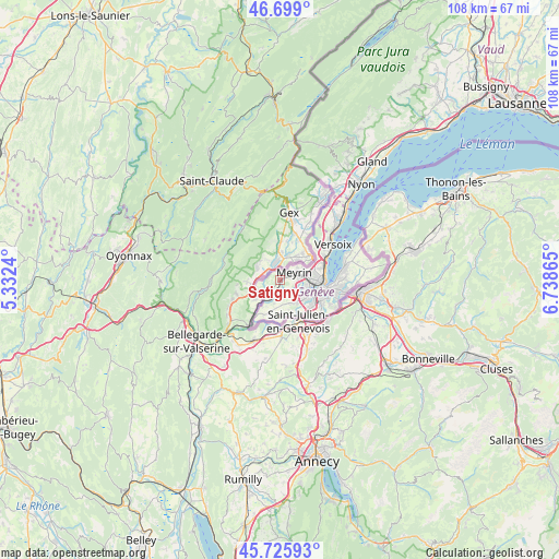
Satigny GPS coordinates[2]
46° 12' 52.632" North, 6° 2' 7.908" East
| Map corner | latitude | longitude |
|---|---|---|
| Upper-left | 46.699°, | 5.3324° |
| Center: | 46.21462°, | 6.03553° |
| Lower-right: | 45.72593°, | 6.73865° |
| Map W x H: | 108.2×108.2 km | = 67.2×67.2mi |
| max Lat: | 47.76737° ⇑93.9% North |
| Satigny: | 46.21462° |
| min Lat: | ⇓6.1% South 45.83203° |
| min Long | Satigny | max Long |
| 5.97153° | 6.03553° | 10.44624° |
| W 0.2%⇐ | ⇒99.8% E |
Elevation
Elevation of Satigny is 422 m = 1385 ft, and this is 136.2 m = 447 ft below average elevation for this country.
| Max E: |
1845 m = 6053 ft | 79.7% |
| Avg. | 558.2 m = 1831 ft | |
| Satigny | 422 m = 1385 ft | |
Min E: |
197 m = 646 ft | 20.3% |
See also: Switzerland elevation on elevation.city.
Geographical zone
Satigny is located in North temperate zone (between Tropic of Cancer and the Arctic Circle). Distance of this North polar circle is 2262.6 km =1405.9 mi to North.| Distance of | km | miles | from Satigny |
|---|---|---|---|
| North Pole | 4868.5 | 3025.1 | to North |
| Arctic Circle | 2262.6 | 1405.9 | to North |
| Tropic Cancer | 2532.7 | 1573.7 | to South |
| Equator | 5138.6 | 3193 | to South |


Nearby cities:
15 places around Satigny: (largest is in red/bold)
• Aire-la-Ville
2.7 km =1.7 mi,  168°
168°
• Bernex
5.2 km =3.2 mi,  144°
144°
• Cartigny
4.7 km =2.9 mi,  195°
195°
• Chancy
8.7 km =5.4 mi,  214°
214°
• Confignon
5.9 km =3.7 mi, 140°
• Dardagny
3.8 km =2.4 mi,  235°
235°
• Genève
8.6 km =5.3 mi,  99°
99°
• Lancy
6.7 km =4.2 mi,  114°
114°
• Le Grand-Saconnex
6.8 km =4.2 mi,  73°
73°
• Les Avanchets
5.6 km =3.5 mi,  82°
82°
• Meyrin
4.1 km =2.5 mi,  57°
57°
• Onex
6.2 km =3.9 mi,  123°
123°
• Plan-les-Ouates
8.1 km =5 mi,  129°
129°
• Soral
7.9 km =4.9 mi,  175°
175°
• Vernier
3.8 km =2.4 mi,  85°
85°
Sources, notices
• [Note1] Compared only with cities in Switzerland existing in our database
• [Src1] Map data: © OpenStreetMap contributors (CC-BY-SA)
• [Src2] Other city data from geonames.org with taken over terms of usage.
• [Src3] Geographical zone / Annual Mean Temperature by Robert A. Rohde @ Wikipedia
