Chancy geodata
Chancy (Geneva) is a seat of a third-order administrative division; located in Switzerland in Europe/Zurich (GMT+2) time zone. With population of 942 people, there are 1380 cities with bigger population in this country. Compared to other cities in Switzerland, 96.6% of cities are located further ↑North; 100% of cities are located further →East and 94.8% of cities have higher elevation than Chancy. Note1


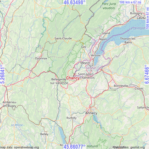
Chancy GPS coordinates[2]
46° 9' 0.108" North, 5° 58' 17.508" East
| Map corner | latitude | longitude |
|---|---|---|
| Upper-left | 46.63498°, | 5.26841° |
| Center: | 46.15003°, | 5.97153° |
| Lower-right: | 45.66077°, | 6.67466° |
| Map W x H: | 108.3×108.3 km | = 67.3×67.3mi |
| max Lat: | 47.76737° ⇑96.6% North |
| Chancy: | 46.15003° |
| min Lat: | ⇓3.4% South 45.83203° |
| min Long | Chancy | max Long |
| 5.97153° | 5.97153° | 10.44624° |
| W 0%⇐ | ⇒100% E |
Elevation
Elevation of Chancy is 362 m = 1188 ft, and this is 196.2 m = 644 ft below average elevation for this country.
| Max E: |
1845 m = 6053 ft | 94.8% |
| Avg. | 558.2 m = 1831 ft | |
| Chancy | 362 m = 1188 ft | |
Min E: |
197 m = 646 ft | 5.2% |
See also: Switzerland elevation on elevation.city.
Geographical zone
Chancy is located in North temperate zone (between Tropic of Cancer and the Arctic Circle). Distance of this North polar circle is 2269.8 km =1410.4 mi to North.| Distance of | km | miles | from Chancy |
|---|---|---|---|
| North Pole | 4875.7 | 3029.6 | to North |
| Arctic Circle | 2269.8 | 1410.4 | to North |
| Tropic Cancer | 2525.5 | 1569.3 | to South |
| Equator | 5131.4 | 3188.5 | to South |


Nearby cities:
15 places around Chancy: (largest is in red/bold)
• Aire-la-Ville
7.1 km =4.4 mi,  50°
50°
• Bernex
8.5 km =5.3 mi,  69°
69°
• Carouge
13.4 km =8.3 mi,  75°
75°
• Cartigny
4.6 km =2.9 mi, 54°
• Confignon
9.1 km =5.7 mi, 73°
• Dardagny
5.4 km =3.4 mi,  19°
19°
• Lancy
11.9 km =7.4 mi, 68°
• Les Avanchets
13.2 km =8.2 mi, 52°
• Meyrin
12.6 km =7.8 mi,  41°
41°
• Onex
10.8 km =6.7 mi, 69°
• Plan-les-Ouates
11.4 km =7.1 mi, 79°
• Satigny
8.7 km =5.4 mi,  34°
34°
• Soral
5.5 km =3.4 mi,  97°
97°
• Troinex
13.6 km =8.5 mi, 83°
• Vernier
11.5 km =7.1 mi, 49°
Sources, notices
• [Note1] Compared only with cities in Switzerland existing in our database
• [Src1] Map data: © OpenStreetMap contributors (CC-BY-SA)
• [Src2] Other city data from geonames.org with taken over terms of usage.
• [Src3] Geographical zone / Annual Mean Temperature by Robert A. Rohde @ Wikipedia
