Aire-la-Ville geodata
Aire-la-Ville (Geneva) is a populated place; located in Switzerland in Europe/Zurich (GMT+2) time zone. With population of 1,100 people, there are 1267 cities with bigger population in this country. Compared to other cities in Switzerland, 94.5% of cities are located further ↑North; 99.7% of cities are located further →East and 93.2% of cities have higher elevation than Aire-la-Ville. Note1


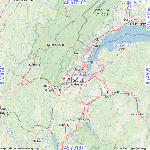
Aire-la-Ville GPS coordinates[2]
46° 11' 26.052" North, 6° 2' 34.332" East
| Map corner | latitude | longitude |
|---|---|---|
| Upper-left | 46.67516°, | 5.33974° |
| Center: | 46.19057°, | 6.04287° |
| Lower-right: | 45.70167°, | 6.74599° |
| Map W x H: | 108.2×108.2 km | = 67.2×67.2mi |
| max Lat: | 47.76737° ⇑94.5% North |
| Aire-la-Ville: | 46.19057° |
| min Lat: | ⇓5.5% South 45.83203° |
| min Long | Aire-la-Ville | max Long |
| 5.97153° | 6.04287° | 10.44624° |
| W 0.3%⇐ | ⇒99.7% E |
Elevation
Elevation of Aire-la-Ville is 377 m = 1237 ft, and this is 181.2 m = 594 ft below average elevation for this country.
| Max E: |
1845 m = 6053 ft | 93.2% |
| Avg. | 558.2 m = 1831 ft | |
| Aire-la-Ville | 377 m = 1237 ft | |
Min E: |
197 m = 646 ft | 6.8% |
See also: Switzerland elevation on elevation.city.
Geographical zone
Aire-la-Ville is located in North temperate zone (between Tropic of Cancer and the Arctic Circle). Distance of this North polar circle is 2265.3 km =1407.6 mi to North.| Distance of | km | miles | from Aire-la-Ville |
|---|---|---|---|
| North Pole | 4871.2 | 3026.8 | to North |
| Arctic Circle | 2265.3 | 1407.6 | to North |
| Tropic Cancer | 2530 | 1572.1 | to South |
| Equator | 5135.9 | 3191.3 | to South |


Nearby cities:
15 places around Aire-la-Ville: (largest is in red/bold)
• Bernex
3 km =1.9 mi,  121°
121°
• Carouge
7.5 km =4.7 mi,  98°
98°
• Cartigny
2.5 km =1.6 mi,  224°
224°
• Chancy
7.1 km =4.4 mi,  230°
230°
• Confignon
3.7 km =2.3 mi, 120°
• Dardagny
3.7 km =2.3 mi,  278°
278°
• Lancy
5.5 km =3.4 mi,  90°
90°
• Le Grand-Saconnex
7.6 km =4.7 mi,  52°
52°
• Les Avanchets
6.1 km =3.8 mi,  55°
55°
• Meyrin
5.6 km =3.5 mi,  30°
30°
• Onex
4.6 km =2.9 mi, 99°
• Plan-les-Ouates
6.2 km =3.9 mi,  113°
113°
• Satigny
2.7 km =1.7 mi,  348°
348°
• Soral
5.2 km =3.2 mi,  180°
180°
• Vernier
4.4 km =2.7 mi, 47°
Sources, notices
• [Note1] Compared only with cities in Switzerland existing in our database
• [Src1] Map data: © OpenStreetMap contributors (CC-BY-SA)
• [Src2] Other city data from geonames.org with taken over terms of usage.
• [Src3] Geographical zone / Annual Mean Temperature by Robert A. Rohde @ Wikipedia
