Saint-Imier geodata
Saint-Imier (Bern) is a populated place; located in Switzerland in Europe/Zurich (GMT+2) time zone. With population of 5,220 people, there are 324 cities with bigger population in this country. Compared to other cities in Switzerland, 55.9% of cities are located further ↑North; 87.9% of cities are located further →East and 89.6% of cities have lower elevation than Saint-Imier. Note1


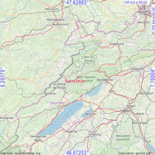
Saint-Imier GPS coordinates[2]
47° 9' 10.224" North, 6° 59' 48.912" East
| Map corner | latitude | longitude |
|---|---|---|
| Upper-left | 47.62885°, | 6.29379° |
| Center: | 47.15284°, | 6.99692° |
| Lower-right: | 46.67253°, | 7.70004° |
| Map W x H: | 106.3×106.3 km | = 66.1×66.1mi |
| max Lat: | 47.76737° ⇑55.9% North |
| Saint-Imier: | 47.15284° |
| min Lat: | ⇓44.1% South 45.83203° |
| min Long | Saint-Imier | max Long |
| 5.97153° | 6.99692° | 10.44624° |
| W 12.1%⇐ | ⇒87.9% E |
Elevation
Elevation of Saint-Imier is 814 m = 2671 ft, and this is 255.8 m = 839 ft above average elevation for this country.
| Max E: |
1845 m = 6053 ft | 10.4% |
| Saint-Imier | 814 m 2671 ft | |
| Avg. | 558.2 m = 1831 ft | |
Min E: |
197 m = 646 ft | 89.6% |
See also: Switzerland elevation on elevation.city.
Geographical zone
Saint-Imier is located in North temperate zone (between Tropic of Cancer and the Arctic Circle). Distance of this North polar circle is 2158.3 km =1341.1 mi to North.| Distance of | km | miles | from Saint-Imier |
|---|---|---|---|
| North Pole | 4764.2 | 2960.3 | to North |
| Arctic Circle | 2158.3 | 1341.1 | to North |
| Tropic Cancer | 2637 | 1638.6 | to South |
| Equator | 5242.9 | 3257.8 | to South |


Nearby cities:
15 places around Saint-Imier: (largest is in red/bold)
• Chézard-Saint-Martin
10.8 km =6.7 mi,  206°
206°
• Corgémont
12.1 km =7.5 mi,  67°
67°
• Courtelary
6.4 km =4 mi,  63°
63°
• Dombresson
9.4 km =5.8 mi,  197°
197°
• Grand-Savagnier
11.8 km =7.3 mi, 195°
• Lamboing
11.2 km =7 mi,  111°
111°
• Le Landeron
12 km =7.5 mi,  152°
152°
• Le Noirmont
8.5 km =5.3 mi,  339°
339°
• Les Bois
7.5 km =4.7 mi,  291°
291°
• Les Breuleux
6.5 km =4 mi,  7°
7°
• Lignières
9.3 km =5.8 mi, 145°
• Nods
7.6 km =4.7 mi,  123°
123°
• Saignelégier
11.5 km =7.1 mi,  359°
359°
• Tramelan
11.2 km =7 mi,  45°
45°
• Villeret
1.8 km =1.1 mi, 69°
Sources, notices
• [Note1] Compared only with cities in Switzerland existing in our database
• [Src1] Map data: © OpenStreetMap contributors (CC-BY-SA)
• [Src2] Other city data from geonames.org with taken over terms of usage.
• [Src3] Geographical zone / Annual Mean Temperature by Robert A. Rohde @ Wikipedia
